• We have updated the guidelines regarding posting political content: please see the stickied thread on Website Issues.
That image looks quite convincing but would the aircraft really have stayed in one piece?
If the aircraft had been glided carefully down to the surface of the sea, it could have retained its shape.
I have no doubt that Earhart was capable of landing the plane with such finesse.
 

A former US Air Force officer spent $11M searching for Amelia Earhart's long-lost plane — and may have found it

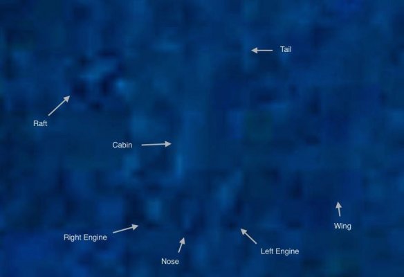
A pilot and former US Air Force intelligence officer believes an image he captured using sonar on a high-tech unmanned submersible may have finally answered one of America's most baffling mysteries: What caused the disappearance of iconic pilot Amelia Earhart at the height of her fame?

Tony Romeo is one of a long line of researchers and hobbyists to have taken up the search for Earhart's distinctive Lockheed 10-E Electra plane.

His expedition, which was carried out using a $9 million high-tech unmanned submersible "Hugin" drone, and a research crew of 16, started last September in Tarawa, Kiribati.

Roughly a month into the trip, the team captured a sonar image of the plane-shaped object about 100 miles from Howland Island — but didn't discover the image in the submersible's data until the 90th day of the voyage, making it impractical to turn back to get a closer look.

65b5c0c36c8f0a134f7a6c89


Experts have shown interest in the finding, with Dorothy Cochrane, a curator at the Smithsonian Institution's National Air and Space Museum, telling The Journal that the reported location where the image was taken was just about right.

https://www.businessinsider.com/son...plane-found-pacific-ocean-2024?op=1&r=US&IR=T

maximus otter
It's certainly intriguing but, unless indicative of wing damage, the sonar image looks rather like an aircraft with swept wings, rather than the straight wings of the Electra.
 
One problem that has plagued searches for the plane over the years is the abundance of wrecked planes from WWII in that general area. Some of the artifacts pulled out of the water in the 60s turned out to be from Japanese planes, if memory serves. The technology of the time was similar in a lot of ways, since the Electra was a very advanced design for the 1930s.

This is an interesting development. I'll have to dive down the rabbit hole and see where this image was taken. Seems like a million to one shot to find something that size in the vast area of ocean where it could be. I read that some other Electras ditched over the years, and remained intact and afloat for a very short time. If that's the plane, then there might well be human remains. That would leave a hundred or so "eyewitness" yarns looking pretty silly.

The article and some comments here make it sound like Amelia was some sort of awesomely skilled pilot. Contemporary accounts from her heyday are not so flattering. It is my belief that if she had been a competent radio operator, they would likely have made it to the island.
 
One of the more compelling theories is that Earhart actually went down quite close to the ship she was radioing, but sank too fast for any searchers to find anything.
 
It's certainly intriguing but, unless indicative of wing damage, the sonar image looks rather like an aircraft with swept wings, rather than the straight wings of the Electra.
That was my first thought looking at the image. Unless as you say there was damage to the wings being forced back on impact but still keeping attached to the fuselage which seems unlikely.
 
What happened to the “executed by Japanese” theory or was that debunked?
Didn't that stem from a Japanese photo showing a harbour with figures vaguely resembling Earhart and Noonan standing on a pier? It caused some excitement for a while, until the photo was positively identified as coming from a Japanese travel book published several years before Earhart's last flight.
 
yeah there was never any good evidence for the Japanese angel, and the tiny bit people came up with was fake.

Anyways here's one where the conclusion was that Amelia just overshot her target and ditched due to running out of fuel:
knowing that her RDF didn't work, and that Noonan's astro-nav was her only way to verify course... I'm impressed she got THAT far.

Note his local time measures. Amelia took off hours before dawn. This way it's still dark enough for Noonan to get a fix from stellar cartography.
 
Compare the most recent "discovery" against the real L10E in the Orona lagoon.
 

Attachments

  • OronaL10E.jpg
    OronaL10E.jpg
    33.8 KB · Views: 20
Smudge.

Have we any test shots of known intact plane wrecks to compare??
 
If you have an old version of Google Earth, you can get down on top of the object and really see some detail. When the newer versions of GE came out, and users downloaded/installed it onto thier computers, the install wiped the older version(s) and now the treetop eye view is no longer available; the application switches to "street view" automatically. This after concerns about backyard privacy. About 130 feet above terrain/sea surface is as close as one can get.
Anyhow, this image from about 75', shows the better detail that was available with the older GE version. The angles do not need any correction as refraction doen't change angles the way refraction changes linear dimensions. You can check that 23.5 degrees with a compass and the overhead image of the Electra.
Upclose1.png
 
Back
Top