• We have updated the guidelines regarding posting political content: please see the stickied thread on Website Issues.

Earth Oddities Seen In Google Maps / Earth / Street View

Seems a bit overkill to me. Still, Im sure archaeologists of the future will like it
 
A beautiful monument to the memory of the victims of a terrible ocurrence.
 
Amazing story, but surely it's just going to get smothered by the desert?
 
Father_Ted said:
Amazing story, but surely it's just going to get smothered by the desert?
You mean like the Nazca Lines have been?
 
Ah, but the Nazca lines are on bare rock, not shifting sand dunes.

Memorials should be restrained and in good taste (Unlike the Victorian tombstone for Flora Mcleod, which is so big it has to be propped up.)
 
No they are not. The Nazca lines were made by removing the pebbles on the surface of the earth and then excavating down to an average depth of 10-15cm.
 
Monstrosa said:
You mean like the Nazca Lines have been?.

No, I meant like the wreckage of the plane was, as is evident from some of the photos in the linked article.
 
Heres the
Latitude: 54°31'18.38"N
and
Longitude: 126°22'11.81"W
 
Father requests that an image of his murdered son be removed from Google Maps.
http://www.theguardian.com/technology/2013/nov/19/google-maps-dead-son-californian

Google Maps image shows my dead son, says Californian man

Richard Barrea says he became aware of image of his son – who was killed in 2009 – earlier this week

theguardian.com, Associated Press in Richmond, California. 19 November 2013

[ The Google Maps image that Richard Barrea says shows his dead son (blurred). Photograph: Google ]

A man from the San Francisco Bay Area wants Google Maps to remove an aerial image that shows the body of his 14-year-old son, who was shot and killed in 2009.

Richard Barrea told KTVU-TV over the weekend that he became aware of the image of his son Kevin earlier in the week. He said he wants Google to take down the image out of respect for his son, but it wasn't clear whether he had asked Google directly to take it down.

"When I see this image, it's still like that happened yesterday," Barrera told the news station on Sunday. "And that brings me back to a lot of memories."

The image shows what appears to be a body on the ground near a railway line with several other people, presumably investigators, and what looks like a police car nearby. It was visible on Google's website on Monday.

Kevin's body was found on a path near railroad tracks that separate North Richmond from San Pablo on 15 August, 2009. His killing remains unsolved.

Police believe Kevin was killed in the same spot the night before his body was found. They have not established a motive for the killing or identified any suspects.
 
ChrisBoardman said:
if you look on bing maps but don't fully zoom in it looks there also

http://binged.it/1dRMTXd
:shock: That looks to have been take earlier, before the authorities got to the scene. The railway carriages on the right are also further up - perhaps they were moved to shield sight of the body, either by the police or someone else? Awful thing for the father to have to see, but I wonder if Google maps images could be used to help solve a crime?
 
:shock: What a bunch of tw*ts at google.

I'm sure they could have made a little tweak there.
 
I'm guessing though that with all the images Google take there was bound to be one like this somewhere.
While I agree that this is distressing for the father to see, no one is making him look it it.
I would imagine that it is tricky for Google to remove the image as they have nothing to replace it with. However they could 'fuzz it out'.
 
It's a satellite image, so could take a while to replace properly.
 
There isn't anything that nasty to see, you can just make out a person on the ground, cop car, cops - no detail like you could say the person was alive or dead without knowing.

Blurring is indeed very common on google maps, I forget if it was a thead I started a few years ago, but we had one where numerous instances of the word 'cock' in street names were blurred out.
 
Yeah! I just checked Street View and Cockshut Road in Lewes is deffo blurred out!
 
Thing is, I bet barely anybody had even seen the body on Google Earth, much less figured out what it was. Now thanks to the story the image is all over the internet and people have been deliberately logging on to see it. If you don't want people to see pictures of your dead kid don't sell the story to the newspapers and say when specifically it is.

@Zoffre: Well, there was that one time someone found their partner cheating on them thanks to Streetview...
 
http://www.juxtapoz.com/current/what-on ... treet-view

Hopefully not posted I scrolled a few pages but this thread is huge

Article based on this the guys site which contains not just weird Google earth stuff but quite beautiful shots from Google Earth

http://9-eyes.com/

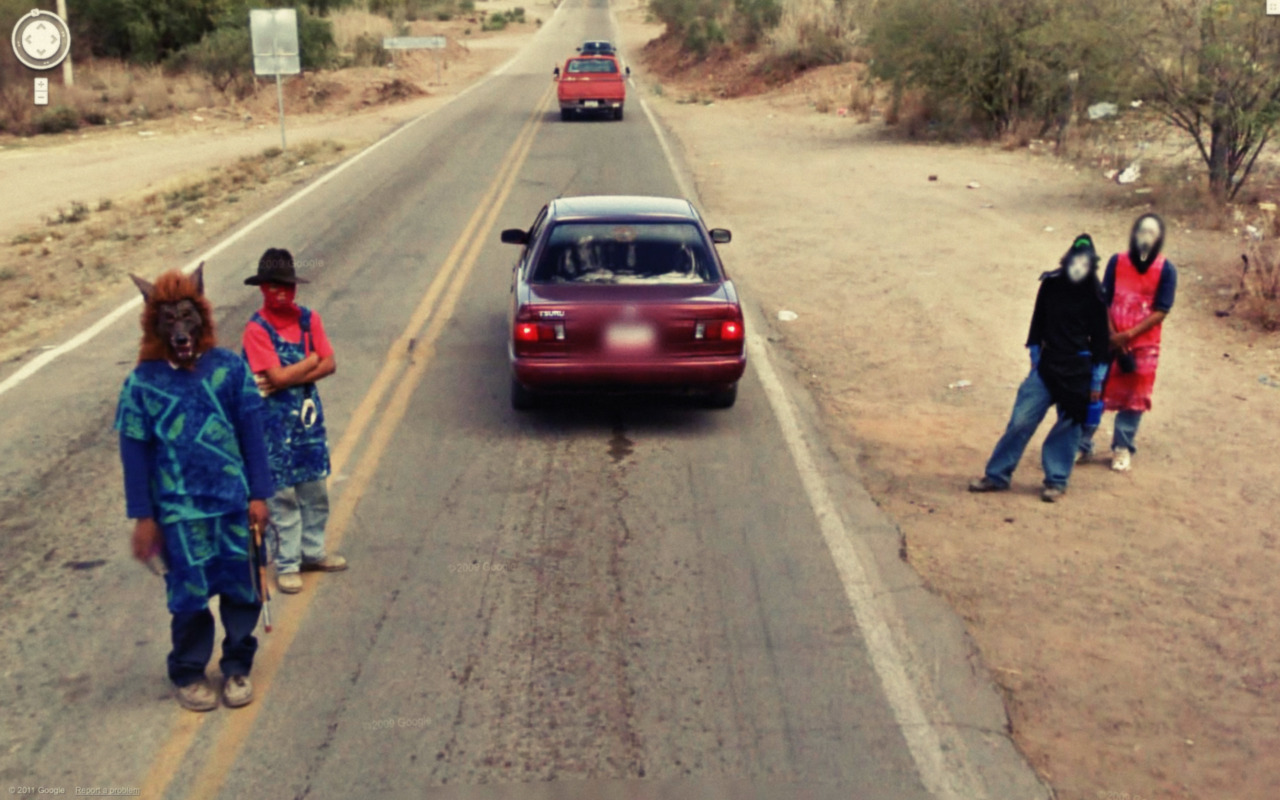
tumblr_lws3ljkZAO1qzun8oo1_1280.jpg
 
Have the faces of the two guys on the right been deliberately blurred by Google (like the number plate)? Not suggesting the Wolf Man is Photoshopped in by the company, of course.
 
That is a fairly common practice, also car number plates get blurred out a lot, although I couldn't tell you why some are still visible and some are not.

Maybe it's done automatically but depends on what the detection algorithm picks up, or doesn't?
 
Could be the software is a bit unreliable? Doesn't explain Wolfie, though.
 
Google's software does indeed automatically blur identifying information like faces and number plates. It can miss them, and I think Google then depend on people to alert them to the errors so they can correct them manually.

It doesn't blur out non-human faces, as the photos of Horseboy attest. And it did initially miss the shot of the couple allegedly having sex by the side of a highway in South Australia (I suspect they staged the photo after seeing the Google car, and chasing it down.)
 
Back
Top