• We have updated the guidelines regarding posting political content: please see the stickied thread on Website Issues.

Experimental Travel

stuneville said:
I'm off on an experimental bike-ride shortly. I know roughly where I'm going (it's out of the city), and have a destination in mind, but I'm not taking any maps and trying to avoid any main roads, just relying on my own sense of direction to see how I fare.

Will let you know my findings...


I got lost...
anyway I'll be off on another adventure tomorrow, this time well aware of where I'm headed, but going to see if there are any other routes I hadn't previously noticed.
 
stuneville said:
I got lost...
That's the way to do it!

When things go to plan, that's just a journey - when they don't, it becomes an adventure, a discovery of the unexpected. 8)

(I discovered that the footpaths on my OS map do not always match reality... :( )
 
I've recently purchased a "Past & Present" map of the local area, from Tesco of all places. It has 4 maps covering the same 10x10 mile area, but uses maps from 1834, 1902, 1921 and the present day. The comparison is fascinating for anyone with even a passing interest in local history.

What might be even more fascinating would be to plan a journey using only the roads which existed in 1834. Without being able to use some main roads and bypasses which exist now, I'll bet that most of us would discover whole road networks of which we were previously unaware. I appreciate that this would probably apply most to people living on the edge of towns, with countryside nearby, but almost all of us could discover something new about our area.

So go on - take a look in the "local books" section of your nearest Tesco superstore. It won't be well-advertised, but it'll be well worth the hunt. The maps are by Cassini, and the 4-in-1 Past & Present maps can be seen on Cassini's website.

EDITED to correct mistyped link
 
I'm off to London on Sat by bus jet bus train! Attending the CPGB Summer School in New Cross. Assembling goods to trade with Sarf Londoners now.
 
Peripart said:
I've recently purchased a "Past & Present" map of the local area, from Tesco of all places. It has 4 maps covering the same 10x10 mile area, but uses maps from 1834, 1902, 1921 and the present day. The comparison is fascinating for anyone with even a passing interest in local history.
Thanks for that info.

I've used old maps a lot in historical research (local libraries usually have an interesting collection). One thing I found is that roads can move! In Falmouth there is a Marlborough Road, as well as a Marlborough Avenue a short distance away. On the older maps these roads were part of one continuous track leading across undeveloped land to a large house called Marlborough House. But when new housing was built on the land in Victorian times, Marlborough Road was 'straightened', and so no longer leads directly to the Avenue.

Several towns have little booklets giving historical information as they guide you round the town, which can make a walk more interesting.
 
Today I decided to walk from A to B (where a road has been closed due to subsidence over old mine workings) and then onto C, to get a bus home.

Well, I got from A to C alright, but somehow I bypassed B!

I'd studied the map before I set off, and it seemed straightforward. Early on I found a signpost to B, and passed a railway and a stream I expected. Then I came to a T-junction where the road signs gave no clue where B was! I could have checked the map again, but decided to take pot luck. (When I did check the map later I was none the wiser, however. It was only when I got back to the computer and checked a larger scale map online that I was able to retrace my route. The T-junction was very close to B, which was in fact much smaller than other maps suggested.)

Arriving at C, I found I had just 5 minutes wait for the next bus. A woman there was also waiting for it. The traffic in the village was surprisingly heavy both ways (fairly continuous, but stop-start stuff).

This woman kept walking out into the road to see if the bus was coming, much to the consternation of the motorists, some of whom thought she was trying to cross the road! Why I don't know - it wasn't as if the bus could have whizzed past us. But as the bus arrived 15 minutes late, this performance went on for some time!

Still, it was apt to finish a Fortean walk by meeting one of the Strange Folk.. 8)
 
I revisited Carn Brea today to take some photos, the weather being good.
The 'experimental' bit came in via my approach: the ascent seemed easier from the south, but this meant catching a (twice-a-day!) bus to the village of Carnkie.

Anyway, that worked OK (apart from a mystery with the bus number - the timetable says it's the 42, but the bus claimed to be a 342...). Got to the summit and took my pics - weather and visibility were excellent - if the Earth wasn't curved, I could have seen Ireland!

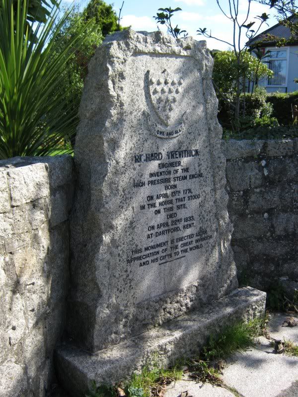
The climb down was hard with my arthritic knees, but eventually I found myself in the level and suburban streets of Pool. And here I unexpectedly stumbled across a memorial to Richard Trevithick, the inventor of the steam locomotive!

IMG_0492pb.jpg


(Which was nice! And then I got to a bus stop just a minute before my bus home was due - which was also nice!)
 
In general I'm scared to try the bus thing you did, although once I went on a bus to get ten minutes away from my house and missed my stop. I decided to see if the bus would go to any other interesting place so I stayed on for another hour and a half and ended up two towns away from home. It was kind of creepy because when I finally got off the streets were all empty and it was the middle of winter.
edit: I mean it was the middle of winter when I got on too, but you know it was cold and creepy and icy everywhere.
 
I need exercise to get my weight down, but my local walks are getting too familiar. I wanted somewhere new, but not too far away, so I looked on the local OS map and found a country road I'd never been down before. From the map it didn't look that interesting, but I wanted the exercise, so I caught a bus to my start point.

The walk was pleasant enough, despite an early threat of rain. Lots of daffodil fields (mainly white ones), and a few distant views.

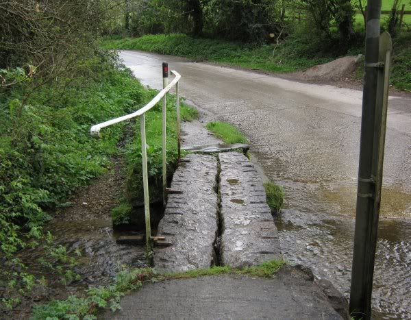
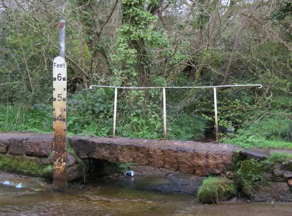
But the road headed downhill, and eventually I found a shallow ford. For the benefit of foot travellers, there was a small clapper bridge over the stream.
http://en.wikipedia.org/wiki/Clapper_bridge
(Cornwall is not mentioned in this piece, and I'd never heard of this particular example either.)

IMG_0618.jpg


IMG_0620.jpg


So, a boring walk for the sake of exercise turned up a little-known local artefact! :D
 
Newer bridges:

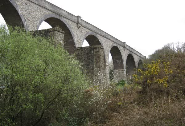
A little later in the walk, I reached the Carnon valley viaduct, built for the GWR by Brunel (no doubt with his own fair hands! ;) )

The buttresses in front of the viaduct supported the wooden trestle bridge that was really Brunel's work. The granite viaduct was constructed later, in the 1930s, apparently.

IMG_0621.jpg
 
New York cabbie picks up $5,000 fare to California

New York taxi driver Mohammed Alam has picked up the fare of a lifetime - $5,000 (£3,000) to drive across the US to Los Angeles.
Investment banker John Belitsky said he and friend Dan Wuebben wanted to do something "magical".
They decided on a cab ride to LA and struck the deal with Mr Alam after finding him at LaGuardia Airport.
The 2,448-mile trip took six days and included a stop in Las Vegas where the friends won $2,000.

Mr Belitsky, of Leonia, New Jersey, and Mr Wuebben, of Queens, New York, haven't yet said how they intend to get back to the East Coast.
But Mr Alam says a friend will help him make the drive back home.

The epic trip has been documented by Mr Belitsky on his Twitter page.
On 22 April, after their winning streak in Las Vegas, he tweeted: "Woke up Alam to a shower of $100 bills at sunrise." :D

New York news blog NYU Local estimated that the trip would have cost $17,000 (£10,000) if the meter had been running for the whole trip

http://www.bbc.co.uk/news/world-us-canada-13179413
 
Forecast of wall-to-wall sunshine today, so I had a day out. I had a destination in mind, but then I found I'd have to wait over an hour for a bus connection, so I went to another bus stand to catch the first bus there to anywhere interesting - which turned out to be Veryan. I'd only been there once before (and that was actually back in 2006, I realised later).

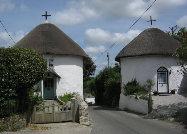
The journey was interesting in itself, but Veryan is famed for its Round Houses, which somehow I'd missed before. We passed two going into the village, but I couldn't be bothered to walk back uphill to photograph them.

Instead I walked in the opposite direction, towards the coast, and coincidentally towards a hotel I'd read about on a website just the day before:
http://www.telegraph.co.uk/travel/hotel ... eview.html

And blow me if I didn't discover two more Round Houses!

IMG_0654.jpg


(They are round so there aren't any corners for the devil to hide in - allegedly!)

It was a lovely warm day, but my 1940s knees are none too good on 2011 hills, so I decided to turn back before the hotel. But as I did, a lorry stopped by me, and the driver asked if I knew where Nare Head is. I said he'd see it, just around the next corner, but (as he was carrying live sheep) he clearly wasn't looking for a coastal headland! We both had the same OS map, which didn't show any Nare Head Farm, so I left him trying without success to ring a contact number on his mobile. Later he passed me on the way back to Veryan, and gave me a wave.

One thing I missed (checking an online map later) was Veryan Castle, some sort of prehistoric earthwork. Otherwise it was an unplanned but interesting day.

But the sheep lorry made me think - could that have been some weird practical joke, sending the driver to Nare Head? :?
 
Got a bus to Redruth, then caught the first bus away from there, which went to Portreath. Very pleasant, but I've been there several times before. But later, on checking the timetable more carefully, I realised that that bus continued on to Tehidy Park East Lodge...

Now I've never been to Tehidy Park (an old country estate) before, because the bus connections used to be too awkward, but now I realised I was just minutes away, so I decided to catch the next bus there. But when it arrived, the driver was sure he didn't go there! (Admittedly I asked for Tehidy Park East Gate, instead of Lodge, but you'd expect him to make the connection.)

So I passed another hour in Portreath and then caught the next bus to Camborne - which did indeed go past Tehidy Park East Lodge! :evil:

Back home, I double-checked the maps and timetables. And that bus route is the only one that does pass Tehidy Park East Lodge! So that pesky driver didn't know his route very well (perhaps he'd never been asked for that stop before, although it is printed in the timetable). I'm making a wax model of him to stick pins in.... :twisted:

But the bad news is that the bus connections are still awkward: in theory the Portreath bus leaves Redruth a minute before the Falmouth bus gets in, so it was only luck that I happened to make the connection today.

Well, the forecast is good for tomorrow, so with my newly-updated local knowledge I may try again... Tehidy or bust!

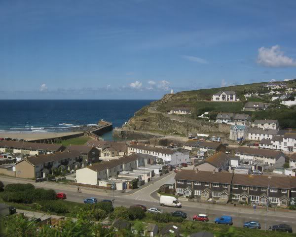
One bonus from today - I took a couple of pics of Portreath from the bus on the hill as it left town, and although I was shooting over my shoulder, one of the pics had a dead-level horizon and was well-focussed! :D

Portreath.jpg
 
rynner2 said:
So that pesky driver didn't know his route very well (perhaps he'd never been asked for that stop before, although it is printed in the timetable). I'm making a wax model of him to stick pins in.... :twisted:

During the time I lived in your country, I met a bus driver who changed the destination signage once the riders were aboard. It was an adventure, all right, but I was really young and had to find my way back to where I was lodging in a city I barely knew at all.

However, I was lodging with the Mayor and his family, and after asking where I had been all day, he took it upon himself to have a rather lengthy talk with the transportation department there. Seems like it wasn't the first time signage got changed.

I'm really enjoying your posts and your pics. Please keep going!
 
Well, I got back to Tehidy Park. Straightforward travel planning, except that one bus ran 20 minutes late... :roll:

But I was rather disappointed, on the whole. The park consists largely of woodland walks, and while trees and dappled sunlight are pleasant enough, I find a little goes a long way!

I'd hoped for some good views of the old country house, but that was in an area reserved for residents only.

There are a couple of ponds and a lake to relieve the woodland tedium, but it's hard to photograph swans or even gulls in bright sunshine because of contrast issues.

Now I don't like to walk 'there and back again', so I was looking for an alternative exit. I had a large-scale map which suggested a couple of possibilities, but as I trudged ever further into the woods these seemed to evaporate. And again I felt the fear of being trapped in woodland - I hadn't seen anyone else for ages, and I don't have a mobile phone. If I'd twisted my knee or sprained my ankle I might not have been found for days!

I'd followed the edge of the woods, but they were fenced with barbed wire, presumbably to keep farm animals in the fields, but that also kept me in the woods! To cut a long story short, I found an escape route which led into someone's back garden! But I was so desperate to get away from the woods I didn't care, and luckily no-one seemed to be home to notice me, so I made my way to a minor road and a level walk back to 'civilization' (ie. somewhere I could catch a bus!).

Really I don't like woods - they seem very lifeless, although you'd think they'd be full of twittering birds, squirrels, etc. I prefer open country with distant views of hills and a glimpse of an estuary or the sea.

Eventually I found a bus stop and shelter, but there was no timetable posted. I had my own timetable, so I sat in the shelter to see when the next bus was due. But the shelter was set back in foliage, and I suddenly worried that I could be sat there while a bus went straight by! So I moved out, and amazingly a bus was coming - I signalled frantically and he stopped. (Did I have a pyschic moment, or was it just coincidence?)

An odd day. I'd noticed some of the details on my map did not match reality, even though I thought it was one of my newer maps. But when I checked, it was last updated in 1997!

At least I wasn't arrested for trespassing!
 
I think this fits in here:

Around the world in our home-made plane (... and we’re still speaking to each other!)
By Jonathan Petre
Last updated at 10:45 PM on 1st October 2011

After a year and a day, 99 flights, 23 countries and bags of teamwork, an intrepid couple have flown around the world in a tiny home-made plane they spent 16 years building.
Retired British Airways pilot Patrick Elliott and his wife Linda Walker are believed to be the first married couple to have circumnavigated the globe in a home-built aircraft.
On their epic voyage they diced with death and saw wonders including the Taj Mahal and the Pyramids at Giza.

But according to Linda, 57, their greatest achievement is ‘the fact that we’re still speaking’.
The former City worker said: ‘You are cooped up in a tiny cockpit together and when you land you can be in stressful situations, unable to speak the language and having to think on your feet. But we worked brilliantly as a team. I can’t wait for our next adventure.’

The couple used 1,320 gallons of fuel costing £12,000 and Patrick admitted it probably would have been cheaper to get first-class tickets round the world, ‘but that would be missing the point’.
He said: ‘Now we are home, it’s hard to believe we have actually done it.’ 8)

The pair, from Reigate in Surrey, started work on the plane, a Rutan Long-EZ, in 1991 between Patrick’s BA flights.

They paid £500 for a third-hand manual of instructions and plans for the self-build aeroplane written by leading Nasa engineer Burt Rutan.
Patrick said: ‘As a BA pilot, I was flying passengers all over the world but I had only 24 hours at each destination.
'I didn’t expect to take 16 years. I had to extend the garage half-way through when we outgrew it'
'I wanted the chance to fly round at my own pace and see some of these amazing places. I read about these self-build planes and decided that was how I could do it.

He had to sculpt, shape and put together every part of the body by hand, carefully following the complicated directions, many of them hand-written and drawn.
Each part was made with different types of foam, covered in fibre glass to withstand pressures of flying, then sealed in resin. The couple went shopping all over America for the more obscure parts, bringing them home in four suitcases and a ski bag, and had an engine imported from New York.
Patrick said: ‘I lost count a long time ago of the hours I spent on it. I can’t even guess. The same for the money. I could have easily bought a commercially made aeroplane for the amount it cost.
‘The record for building one is 18 months. I didn’t expect to take 16 years. I had to extend the garage half-way through when we outgrew it.’

Linda said: ‘At first I called it The Canoe. I could never imagine flying in it. Then the wings went on, and it started to look like a real aeroplane. I realised we were really going up in it.’
Their first flight was in 2007 and they took short trips, such as dropping in to the Isle of Wight for ‘a cup of tea’, before venturing further afield.

After 18 months of planning and negotiations with far-flung airfields, they took off around the world in September 2010. The couple spent 241 hours and 22 minutes in the air in the 16ft 7in long plane before returning home last month.
Speaking of the 37,398-mile journey, Patrick, 57, said: ‘The plane was brilliant and was a real talking point wherever we landed and helped us meet some really interesting people.’

He said there had been a couple of hairy moments, especially when making a difficult approach in strong winds to a small landing strip in Crete.
‘I thought the aircraft was going to hit the ground harder than it eventually did. My heart was in my mouth, but we got down safely.’
The couple did an average of 155mph at an average altitude of up to 6,500ft.
They now hope to fly from the north to the south of Africa, before attempting an ambitious journey from Pole to Pole.

Read more: http://www.dailymail.co.uk/news/article ... z1ZcVlkh4K
 
It's such a small plane...where did they put all the luggage?
 
Mythopoeika said:
It's such a small plane...where did they put all the luggage?
Perhaps they had a jumbo jet following behind for that! ;)
 
Now here's a prog that's right up my street: take a bunch of London based thespians exploring Cornwall without maps or satnav!

I'm used to navigating by the sun, but even so I did pick up one or two other tips from this prog, which also explored several areas I've been to.


All Roads Lead Home - Episode 1

Stephen Mangan, Sue Perkins and Alison Steadman travel the UK. Sue Perkins takes charge in Cornwall and leads Stephen Mangan and Alison Steadman from Bodmin Moor to Cape Cornwall.

Stephen Mangan, Sue Perkins and Alison Steadman ditch their maps and compasses and attempt to travel the UK using nature as their only guide. The sun, the trees and even sheep droppings are their new sat nav, all providing clues to point them in the right direction. Each episode is led by one of the trio as they travel to a place of special significance to them.

Sue Perkins takes charge in Cornwall and leads Stephen Mangan and Alison Steadman from Bodmin Moor to Cape Cornwall. But as amateur navigators they soon discover that one wrong turn could mean disaster. Along the way, Sue takes to the skies and consults some wise women as to why her life has led her to Cornwall.

http://www.bbc.co.uk/iplayer/episode/b0 ... Episode_1/
 
Today I went to Hayle to get some photos of the rediscovered sluice gates of Copperhouse Pool North Sluice. They were further east along King George V Memorial Walk than I expected, so rather than go back to my normal bus stop, I continued east. I thought I'd once seen a footpath that way alongside a stream that looked a pleasant route, but I soon found myself on a straight and wide track that I didn't recall seeing before. Maybe I hadn't seen it before, but it shows on the OS map, so maybe it has recently been widened and resurfaced. (There were signs of fresh earthworking either side.)

Halfway along I came to a stone bridge over a stream. It bore a blue plaque saying this was once a railway bridge on the oldest line in Cornwall! Which was nice! It looks like the line originally ran along KGVMW, so maybe it was a branch off the Hayle branch line... I have heard of a railway to a one-time gunpowder works between Hayle and Gwithian. I'll have to check the dates, and the history.

Anyhow, that was an unexpected and pleasing find. I went looking for one piece of history, and then got a bonus! When I check my photos later I'll pass on the details from the plaque. (Unfortuneately the plaques are white lettering on pale blue - not easy to read, and even harder to photograph!)
 
OK, the blue plaques are provided by Hayle Townscape/Cornish Mining World Heritage:

This one reads:

RAILWAY BRIDGE

Hayle Railway, 1837. Unmodified since 1852, when the railway was diverted to its present location by the West Cornwall Railway. The earliest standard gauge bridge in Cornwall.

[Scheduled Ancient Monument]
 
rynner2 said:
It looks like the line originally ran along KGVMW, so maybe it was a branch off the Hayle branch line...
Er, no, because the Hayle Railway existed before the present main line was built!
I have heard of a railway to a one-time gunpowder works between Hayle and Gwithian. I'll have to check the dates, and the history.
I was thinking of:
In 1888, the National Explosive works were established on Upton Towans (giving it the alternative name "Dynamite Towans"). Originally built to supply the local mining industry, it soon grew to supply the military and, during the First World War, employed over 1500 people. The remote location on the Towans proved a wise move as there were a number of accidents resulting in explosions.

Explosive manufacture ceased in 1920, although parts of the site were used as an explosives store until the 1960s. The area is now a nature reserve over which people are encouraged to roam.

http://en.wikipedia.org/wiki/Hayle
National Explosives Works
Upton Towans is the site of the National Explosives Works which was established in 1888 to supply explosives to the local mines. The dunes were flattened and small enclosures made to house individual buildings for the manufacture of the explosives. The enclosures were built to avoid chain reactions when an explosion occurred and although overgrown with vegetation, are still clearly seen today as is the network of single–track railways. On one occasion an explosion occurred in a nitroglycerine plant which broke windows in St Ives and, it was said, was heard on Dartmoor. During the First World War 1800 people were employed and the works supplied cordite to the Royal Navy. The company went into voluntary liquidation in 1919 and closed in 1920 but the storage of explosives continued until the 1960s. The site is now part of the Upton Towans Nature Reserve

http://en.wikipedia.org/wiki/The_Towans
Perhaps this is where I got the 'railway' connection. But presumably "the network of single–track railways" connected to the main line in order to supply the Navy, etc, with munitions.

There's still a house in the area called Dynamite Corner! 8)
 
Here's a chap who gets around a bit:

Mugged, robbed, attacked, strip-searched! That's not going to stop intrepid Penryn explorer
6:00am Friday 14th June 2013 in Falmouth/Penryn .

Tony Clarke, aged 67 has visited the Russian steppes, Kazakhstan, China, South America, across the Andes, through Central America, the US and Canada and around Australia. A serial explorer from Penryn is about to embark on a fresh adventure to the arctic tundra.

Tony Clarke, aged 67, has lived in the town for nearly 40 years but unknown to most of his neighbours, he is an intrepid traveller.
His obsession began in the 1970’s when he and Tim Ferris of Feock Garages undertook a 13-month circumnavigation of the globe in two Minis for the STOP Polio Campaign.

Three more so-called “Bumpy Road Expeditions” followed.
In his specially converted Land Rover, Tony drove from Penryn and through Europe, across the Russian steppes and on through Kazakhstan into China and beyond.
“It is still difficult to obtain permission to drive in China,” said Tony. “The authorities insisted I had a Chinese driving licence, registration and number plates, and a Chinese guide called Tom, who slept most of the time - when he woke, he would ask me where we were.” 8)

A further trip took Tony not only around Australia, but through the centre from north to south and east to west, to make sure he had seen every inch of its stony and desolate tracts.

The most recent expedition, in 2007, saw him drive from southernmost South America, across the Andes, through Central America, the US and Canada to the most northerly point he could drive - the arctic oceans of Alaska.

Along the way Tony has driven the world’s most dangerous roads, including those with sheer drops, burning sands and deep mud.
He has been detained at gunpoint, mugged, robbed, attacked, strip-searched for drugs, interrogated by the military and suffered altitude sickness, dog bites and insects.

“But I have also seen |the world’s incredible wildlife and its magnificent panoramas,” Tony said.
“I have camped on top of a mountain range and in the middle of a desert.
“I have driven with mud up to the axles and the rain forest brushing the sides of the car, and I have never been happier.”

For Tony’s next expedition he will head north towards the Arctic Circle, through Scandinavia and on to the northern tundra of Russia.
He plans to embark on the three month trip this weekend, as a “dry run” before a future adventure that will see him circumnavigate the entire continent of Africa.
“I don’t know if it’s possible to do it,” he said, “but I have been through Africa and I thought next time I would try to go around the edge of it.”

Friend Pete Lochrie said: “If there is an unexplored nook or cranny left on the globe, you can be sure that Tony Clarke will find it.”

http://www.falmouthpacket.co.uk/news/fp ... _explorer/
 
Vintage car from Cornwall travels across America
[video]
27 August 2013 Last updated at 19:32 BST

A couple from Saltash in Cornwall have driven 25,000 miles (40,000km) in an 80-year-old Austin Seven car.
Guy Butcher and his partner Eunice Kratky drove down the western seaboard of North and South America for charity.

The trip started with the car being shipped to Baltimore, and then they drove into Canada before taking a ferry from the Yukon to Alaska to start the drive to the southern tip of Chile.

It took almost nine months in a vehicle which does about 45 miles (70 km) an hour.
The couple are now writing a book about their time on the road.

http://www.bbc.co.uk/news/uk-england-cornwall-23854135

There's a very active Austin Seven group in Cornwall, so I'm not surprised by this, although it is an advance on just turning up to rallies at various Agricultural Shows!
 
A new series that's right up my street: it's really about travel, more than religion, but it's all interesting:

Pilgrimage with Simon Reeve - Episode 1

For centuries pilgrimage was one of the greatest adventures on earth, involving epic journeys across the country and around the world. This series sees Simon Reeve retrace the exciting adventures of our ancestors. He learns about the forgotten aspects of pilgrimage, including the vice, thrills and dangers that all awaited travellers. He explores the faith, the hopes, desires, and even the food that helped to keep medieval Britons and more recent travellers on the road.

Simon embarks on a 400 mile journey to Canterbury from the north of England, beginning at the mystical Holy Island, just off the rugged coast of Northumberland. To reach the island, one of the earliest sites of Christian pilgrimage in Britain, Simon follows a line of posts marking out a crossing that emerges from the North Sea at low tide.

Medieval Britons believed that journeys of endurance, suffering and sacrifice to a holy site would help them find a place in heaven. Now more than half a million visitors make the crossing every year, mostly by car, to enjoy both the rich history of the island and magnificent wilderness.

Travelling further south through England, Simon gets to try medieval food; marvels at the beauty and majesty of Lincoln Cathedral, once the tallest building on the planet; and joins thousands on an annual pilgrimage at a remote village in Norfolk.

Simon discovers the inspiration behind pilgrimage has not always been religious devotion and piety. Pilgrimage was often a chance for long-suffering peasants to get away from a life of drudgery and explore their land. Many were attracted to the road by the opportunity for adventure and an excuse to do a little sinning away from home.

Simon visits the area of London where brothels paid rent to the Bishop of Winchester while tempting passing pilgrims. He learns more about exquisite medieval travel souvenirs that have been discovered in the muddy banks of the Thames.

Heading out of the capital, Simon meets a group of Chaucer enthusiasts who walk the pilgrimage route made famous by the Canterbury Tales, and gets to play the part of a lovelorn Prince during a retelling of a Chaucerian tale.

http://www.bbc.co.uk/iplayer/episode/p0 ... Episode_1/

Duration 60 minutes Available until 9:59PM Tue, 24 Dec 2013
 
Jersey couple see red on ruby wedding trip

A couple from Jersey are celebrating their ruby wedding anniversary with a tour of 40 places with the colour red in their names. 8)
Jo and Peter Fancourt, who started their journey by ferry to Weymouth, where they originally met, have already visited places in Cornwall, Somerset, Bristol and South Wales.
Their mission involves driving 3,000 miles in a car covered in red ribbons.
They have also seen Redcar on Teesside and Redesdale in Northumberland.

Mr Fancourt said: "Every day is a red day. We wake up and say what red clothes can we wear today?"

Knowing their ruby wedding anniversary was coming up they first celebrated with a trip to the Red River in Vietnam, before visiting places closer to home.
Mrs Fancourt said: "Some of them aren't the most picturesque. One place, The Reddings in Gloucester, was actually a council estate."

It is not the first time the couple has ventured on unusual adventures.
They have been house-swapping in America, hostelling around Japan and travelled by train to Siberia and Outer Mongolia.

In the last few days they have visited Red Marshall in Stockton and Redworth and Redford in County Durham.
In the final week of their holiday they plan to visit Red Row, Redesdale Camp and Redesmouth in Northumberland, before heading to Redburn, Red Dial and Red Main in Cumbria.
They are also hoping to visit Redmire in Yorkshire, Redbourne in Lincolnshire and Redmile in Leicestershire, before heading southwards to relevant places in Suffolk, Sussex and Wiltshire.

The couple will return to Jersey on 21 August.

http://www.bbc.co.uk/news/world-europe-jersey-28786975

What a great idea! :)
 
Back
Top