• We have updated the guidelines regarding posting political content: please see the stickied thread on Website Issues.

Researchers believe they are closing in on the actual site of Ravenser Odd.
Yorkshire's 'Atlantis' may finally be revealed

Archaeologists are closing in on a lost medieval town sometimes referred to as Yorkshire's "Atlantis." ...

Also called Ravenser Odd, the town flourished in what is now east Yorkshire along the east coast of England during the Middle Ages before it was lost to the sea.

"It was a major settlement of some 400+ households," Daniel Parsons ... told Live Science ... Historical records say that the site had a sea wall, harbor, prison and marketplace, Parsons said.

A search for Ravenser Odd in November 2021 in part of the Humber River estuary turned up empty; but now the team believes that it is getting closer than ever now that they have narrowed down the remaining area where it could be located. They plan to set out in about two weeks to the estuary for another search. "[We're] very confident we will find some evidence of the settlement," Parsons told Live Science. ...

Founded around 1235, the town was built on a sandbar on the north bank of the Humber River, along a busy trade route. Parts of the coastline began to erode away during the 14th century, leading to destruction of seaside buildings as well as more flooding across the town. ... What remained of the town was completely abandoned after a major storm hit the area in 1362. ...

What are the chances that archaeologists will really uncover Yorkshire's "Atlantis?" A number of scholars who spoke to Live Science were generally optimistic that the team may succeed in discovering the site. ...
FULL STORY: https://www.livescience.com/yorkshire-atlantis-could-be-revealed
 
Keeping my previous post in mind, here is a youtube vid that says google earth shows an underwater city at about 31 N, 24 W. I don't have google earth, but the satellite imagery from google maps shows nothing at that location.


Am I all wet here, or does anyone else see anything that looks like a city there?

I can just make out a roughly square or rectangular shape at that location, but suspect that is down to pixellation and the mosaicking technique employed by Google Earth when compositing images.

31 N, 24 W is approximately 300 miles West of Madeira and 400 miles South of the most southernly of the Azores and so is a bit too far distant to be considered part of either of those archipelagos.
Would love there to be something artificial under the ocean there, but I doubt there is.

city.png
 
I can just make out a roughly square or rectangular shape at that location, but suspect that is down to pixellation and the mosaicking technique employed by Google Earth when compositing images.

31 N, 24 W is approximately 300 miles West of Madeira and 400 miles South of the most southernly of the Azores and so is a bit too far distant to be considered part of either of those archipelagos.
Would love there to be something artificial under the ocean there, but I doubt there is.
What kind of depth are you talking about there? Would it be consistent with Ice Age sea level rise?
 
What kind of depth are you talking about there? Would it be consistent with Ice Age sea level rise?

The location is out in the middle of the Canary Basin, where depths range on the order of 4000-5000 m.
 
The location is out in the middle of the Canary Basin, where depths range on the order of 4000-5000 m.
That's what I thought. And given the geology of the place, it is unlikely that this area was above sea level in the millennia since the last ice age.

Makes a very doubtful case for ruins of a city.
 
An ancient palace has emerged from an Iraqi reservoir after water levels dropped precipitously because of a drought.
A lack of rain and the release of water through the Mosul Dam to relieve dry conditions has led to the Mittani Empire site being revealed.

Another ancient site uncovered, this time due to water levels dropping.

As waters and ice recede under warming conditions, the traces of people and civilizations long gone from the mortal realm emerge. In recent months, Iraq has been hit particularly hard, battered by extreme drought, with the Mosul reservoir shrinking as water is extracted to keep crops from drying.


Amid this crisis, the ruins of an ancient city, submerged for decades, are once again on dry land. Since the dam was created in the 1980s before the settlement was archaeologically studied and cataloged, its re-emergence represents a rare opportunity for scientists to explore it. The archaeological site has been named Kemune.

The ruins consist of a palace and several other large structures, dating back to the Bronze Age in the region, around 3,400 years ago. Scientists think the ruins might be the ancient city of Zakhiku, a bustling center for the Mittani Empire, which thrived on the banks of the Tigris River between 1550 and 1350 BCE.

This isn't the first time that the city has risen from the waters like a lost Atlantis. In 2018, the dam receded enough to give archaeologists a brief window in which to discover and document the ruins, before the water level rose and covered them again.

So, in December of 2021, when the city began to emerge once more, archaeologists were ready to leap in and take advantage of the second brief window.

In January and February of this year, archaeologist Hasan Ahmed Qasim from the Kurdistan Archaeology Organization in Iraq, along with fellow researchers Ivana Puljiz of the University of Freiburg and Peter Pfälzner from the University of Tübingen in Germany, set about mapping the mysterious city.

https://www.msn.com/en-us/news/technology/ruins-of-hidden-3-400-year-old-city-emerge-as-giant-dam-dries-up/ar-AAXTTUF
 
I've had different names for this lost town. I can't remember, and the book that covered it was lent out to a 'friend' and never returned. But there can't be multiple lost cities on the north side of the Humber estuary surely?

The book was called something like 'Lost towns and villages of the British Isles'.

But it is hardly Atlantis? It is historically recorded and the process of it's loss is perfectly understandable, just like Port Royal in Jamaica or Dunwich on the Suffolk coast? Nothing mysterious about it.
 
'Lost city' ruins uncovered

Experts believe that they have uncovered the remains of a medieval city which disappeared 700 years ago near Trellech in Monmouthshire.
Archaeologists have unearthed two buildings dating back to the 1200s.

Historical evidence shows that one of the largest settlements in Wales during 13th century is somewhere in the area.

But archaeologists have said the exact location has never been pin-pointed, and they hope that the excavations have revealed the lost city.


Stuart Wilson, who is part of Monmouth Archaeological Society, said he was convinced the dig would reveal further evidence of the city's existence a few miles south of the present-day village of Trellech.

"For a long time, we thought the city was near the church in the village," he said.


We believe that it was an alien town set up by the Norman French and that in 1296 there was a battle where the Welsh destroyed it
Stephen Clarke

"But we found nothing during our excavations so we started looking elsewhere."

Groups of volunteers have unearthed the remains of two dwellings which they think could be part of the 400-house city, undetected for the past seven centuries.

"I say it's a city because it had so many more burgages [houses] than Cardiff at the time of its existence," said Mr Wilson.

"The first house we found dates to 1250 but we have found evidence that there was a serious fire which destroyed it."

Mr Wilson said they came to the location of what they think is the buried city by studying the landscape for tell-tale dips and flats which suggested that houses had once been there.

They began an excavation and discovered the remains of ancient walls which turned out to be houses.

Chairman of the society Stephen Clarke said he was "convinced" the remains were those of the lost city.


"We believe that it was an alien town set up by the Norman French and that in 1296 there was a battle where the Welsh destroyed it," he said.
"And this is backed up by the evidence of the fire.

"It has been absolutely amazing to find it because for 30 years we were looking for it in the village.

"But we could find nothing on any of the digs we made and now it looks as though we are right on top of it."

It is thought that the settlement housed workers for the iron industry of the area - society members have described it as being the "Medieval Merthyr".

Stuart Wilson is so convinced that they have located the town that he has even bought a field which is believed to have hundreds of the lost city's homes buried in it.

Story from BBC NEWS:
http://news.bbc.co.uk/go/pr/fr/-/2/hi/uk_news/wales/south_east/3559534.stm

Published: 2004/08/13 05:47:59 GMT

© BBC MMIV

More on the search for Trellech.

One spring day in 2002, a farmer noticed something odd about the molehills in his fields. They seemed to be speckled with something; they looked like mouldy crushed strawberries. On closer inspection, he saw that the “seeds” were more like bits of old pottery—chinks of light, as he came to perceive it, from a vanished world.

The farmer, Jonathan Badham, from the village of Trellech in southeast Wales, dutifully brought his observations to the attention of the Monmouthshire Archaeological Society; he was aware, as were many others, of the controversial theory of the society’s treasurer, Julia Wilson, that somewhere to the south of the village, buried beneath the fields, was a medieval city that had been lost for over five hundred years.

The Trellech Jonathan Badham knew was just a small village on a plateau beyond the Forest of Dean but, the Society claimed, this was just a forlorn relic of what had once been an expansive city—for a time, indeed, the biggest in Wales—a powerhouse of industry that had played a definitive role in the protracted wars that had forged medieval Britain and left a permanent mark on the landscape. But there was a hitch. No one could say with absolute authority where the carcass of this great medieval city lay; rival theories had been posited. Could moles boring blind into the earth have succeeded where humans had failed, turning up fragments of the lost city?

It was a delicious proposition, too poetic almost to be true: a second reclamation of the city by the forces of nature. The news reached the ears of a young archaeology graduate called Stuart Wilson, who lived in the nearby town of Chepstow. Wilson was working as a tollbooth operator on the Severn Bridge between England and Wales, policing the crossing between two nations with very different histories. ...

Excerpted from Shadowlands: A Journey Through Britain’s Lost Cities and Vanished Villages. Copyright (c) 2022 by Matthew Green. Used with permission of the publisher, W. W. Norton & Company, Inc. All rights reserved.

https://lithub.com/searching-for-a-lost-medieval-city-somewhere-in-wales/
 
Newly published research indicates the important Parthian Empire stronghold of Natounia has finally been identified.
Lost city, a real-life 'Helm's Deep,' possibly discovered in Iraq

Nestled in a valley shadowed by mountains in Iraqi Kurdistan sits an ancient fortress that archeologists think may be the lost, royal city of Natounia, based on the discovery of intricately carved rock reliefs depicting an ancient leader, a new study finds.

The stronghold, known as Rabana-Merquly, was once part of the Parthian Empire (also known as the Arsacid Empire), which reigned ... between 247 B.C. and A.D. 224. The Parthians were bitter enemies of the Roman Empire, and fought various battles against them for over 250 years ... Now, new research at this 2,000-year-old fortress suggests that it served as one of the empire's regional centers.

During a recent expedition, an international team of archeologists discovered twin rock reliefs ... at the two entrances to the settlement, which is situated at the base of Mount Piramagrun in the Zagros Mountains. The matching reliefs are said to depict a king of Adiabene, a kingdom that was part of the Parthian Empire ...

Prior to this find, the only known depictions of the existence of Natounia (also known as Natounissarokerta), have been documented on several coins dating from the first century B.C., according to a statement.

"The more specific association with the city of Natounia comes from the inscription on that city's rare coins found elsewhere, which locate it 'on the Kapros,' which is the modern Lower Zab River" ...

In addition to the reliefs, which possibly depict Natounissar, the city's founder, or a direct descendant, researchers used drones to explore fortifications that measure approximately 2.5 miles (4 kilometers) along with two nearby settlements, Rabana and Merquly, of which the site is named. ...

"Rabana-Merquly is by far the largest and most impressive site of the Parthian era in the region, and the only one with royal iconography, so it's by far the best candidate [for being Natounia]" ... "Its fortifications enclose naturally defensible terrain and can be viewed as an extension of the surrounding highland landscape. If you're familiar with Lord of the Rings, it's basically a real-life Helm's Deep." ...
FULL STORY: https://www.livescience.com/mountain-fortress-iraq-natounia
 
Here are the bibliographic details and abstract from the published report. The full report is accessible at the link below.


Brown, M., Raheem, K., & Abdullah, H. (2022).
Rabana-Merquly: A fortress in the kingdom of Adiabene in the Zagros Mountains.
Antiquity, 1-17.
doi:10.15184/aqy.2022.74

Abstract
The mountain fortress of Rabana-Merquly was a major regional centre of the Parthian period (first century BC) in the Zagros Mountains of Iraqi Kurdistan. The iconography of two rock-reliefs that show an unnamed ruler suggests an association with the vassal kingdom of Adiabene. The exceptional preservation of the fortress's stone walls, undamaged by later agriculture in this highland location, provides an almost complete example of a large, fortified site with two main intramural settlements. Through its ability to control the surrounding landscape, Rabana-Merquly highlights the role of client states on the peripheries of the Parthian and Roman Empires and illuminates the practicalities of territorial control by state authorities in hinterland regions.

SOURCE / FULL REPORT: https://www.cambridge.org/core/jour...s-mountains/1267306C7EC268AA7AC916E579A7BEAA#
 
A lost village.

Evidence for a "lost village" which was visited by King Edward II has been found near the site of a medieval manor house, a historian has said.

A study using laser imaging technology discovered indications of a settlement near the 12th Century manor house at Ightenhill in Burnley.
Research indicates it had a chaplain, ironworks and brewery and may have been home to dozens of people.
Roger Frost said the site could change the medieval history of the area.
It had always been thought a medieval village on the banks of the River Brun eventually grew into the market town of Burnley, which swallowed up the surrounding estates and hamlets.

https://www.bbc.com/news/uk-england-lancashire-62326217
 

Russian archeologists claim uncovered medieval 'Jewish' Khazar kingdom's capital

Researchers unearth thousands of unique artifacts, including a drawing of what seems to be a menorah, in Russia's Astrakhan Oblast suggesting site may be the lost capital of Atil.

Archeologists discovered thousands of unique artifacts that suggest that the site may indeed be the kingdom's lost capital of Atil.
One of the findings is a drawing of what appears to be a menorah — a seven-branched candelabrum that stood in the heart of the ancient Jewish Temples. Other findings include coins, pottery, rings and more.
The excavation also unearthed part of a medieval fortress about 18 meters long and more than 4 meters wide which will help researchers in learning more about the fate of the city.
Astrakhan Oblast Governor Igor Babushkin announced the discovery on his Telegram channel and said that research into the ancient site will be renewed in 2023.

https://www.ynetnews.com/travel/article/s1ispwdls
 
... Archeologists discovered thousands of unique artifacts that suggest that the site may indeed be the kingdom's lost capital of Atil. ...

NOTE: There are earlier posts in this thread about the elusive Jewish Khazar capital of Khazaria:

https://forums.forteana.org/index.p...n-search-of-vikings-in-iran.20110/post-490371
https://forums.forteana.org/index.php?threads/lost-cities-towns.62182/post-2074447
https://forums.forteana.org/index.php?threads/lost-cities-towns.62182/post-2074672

... all of which refer to the site as "Itil."

According to the Jewish Virtual Library both spellings (Atil; Itil) apply to the lost Khazarian capital.

https://www.jewishvirtuallibrary.org/atil-or-itil-jewish-virtual-library
 
It is interesting to know what became of the Khazars after the Kingdom crumbled.

Koestler's work has largely been discredited (that they became the Ashkenaz Jews,) but it is possible they became the Bukharian Jews of Uzbekistan.
But not certain, as many of themselves believe themselves to be descended from one of the 10 exiled tribes, probably Naphthali.
 
Exhibition and talks about Ravenser Odd at Hull History Centre.

Story of Humber's lost town Ravenser Odd to be told​

4 hours ago
By David McKenna,BBC News
Share
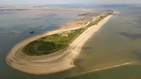
David Nichols Spurn Point on the North bank of the Humber estuary
David Nichols
Ravenser Odd, near Spurn Point, pictured, became a thriving Humber port

The story of a town lost to the sea more than 650 years ago will be told at an exhibition in Hull.

Ravenser Odd, near Spurn Point, was granted its charter, along with Hull, by King Edward I on 1 April 1299.

Those original charters, on loan from the National Archives, will be on display for the first time outside of London.

Archivist Martin Taylor says it is a "real coup" for Hull.

Called Hull/Ravenser Odd: Twin Cities, Sunken Pasts, the exhibition will display the documents along with items from the collection at Hull History Centre.

Ravenser became a thriving Humber port in medieval times. According to author Phil Mathison, it had two MPs, warehouses, a large fishing fleet and "its power rivalled at least Grimsby and Hull".

Over the course of about 100 years, some of the town's buildings were lost to erosion before it disappeared in the 1360s.


In 2022, an underwater sonar search by the University of Hull uncovered sand dunes on the seabed, which suggested stone structures underneath.

Experts said the sonar findings were similar to other sites around the world where ancient buildings have been uncovered. ...

The exhibition opens on Tuesday 26 March and runs until 30 May 2024.

Dr Kathryn Maude, from the National Archives, and Dr Emily Robinson, from the University of Sussex, will give a talk about the history and folklore of Ravenser Odd on 9 April.

https://www.bbc.com/news/uk-england-humber-68626384
 
Back
Top