
What you get up to in private is your own businessI have this urge to punch custard
You are using an out of date browser. It may not display this or other websites correctly.
You should upgrade or use an alternative browser.
You should upgrade or use an alternative browser.
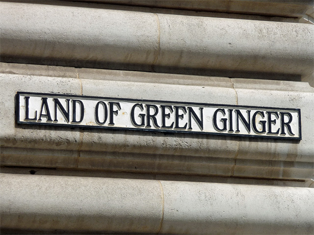
O, To Be In England...
- Thread starter Ronnie Jersey
- Start date
Tunn11
Justified & Ancient
- Joined
- Nov 23, 2005
- Messages
- 2,236
- Location
- Under the highest tree top in Kent
Ah that explains it. Hatches murder plot, fill sock with custard powder and water, batter victim to death, pour away murder weapon.'Custard powder' contains, amongst other things, cornflour.

Mythopoeika
I am a meat popsicle
- Joined
- Sep 18, 2001
- Messages
- 51,656
- Location
- Inside a starship, watching puny humans from afar
In Hull:
maximus otter
Recovering policeman
- Joined
- Aug 9, 2001
- Messages
- 13,944
Hatches murder plot, fill sock with custard powder and water, batter victim to death, pour away murder weapon.
He'll have received his just desserts.
maximus otter
escargot
Disciple of Marduk
- Joined
- Aug 24, 2001
- Messages
- 43,323
- Location
- HM The Tower of London
That's rather Roald Dahl.Ah that explains it. Hatches murder plot, fill sock with custard powder and water, batter victim to death, pour away murder weapon.

I live a couple of miles away from a Candlemas lane. I used to travel past a Seven Hills lane too which I thought must have referred to ancient burial mounds at one time.Your street names have such charm - 'Chesterton Green' and 'Upper Riding' are streaks above boring Main Street or Maple Avenue.
My mother's address was '31 Candlemas Lane', which I always think would make a great book title, if I can ever get my gothic book written!
Best of all though was when I worked at a cottage in the wilds of Hertfordshire a while ago and quite close by was an old bye-way or green lane called Dead Womans Lane. I asked the owner about it but he had never looked into the history of it

Not somebody to be trifled with.He'll have received his just desserts.
maximus otter
Recovering policeman
- Joined
- Aug 9, 2001
- Messages
- 13,944
...in the wilds of Hertfordshire a while ago and quite close by was an old bye-way or green lane called Dead Womans Lane. I asked the owner about it but he had never looked into the history of it
OS 6" to the mile, surveyed 1878-1881
"Dead Womans Lane, believed to be so named because the plague victims of Welei were buried in the adjacent field 'Wayley Close'.
The most credible cause for the desertion of Welei, which disappears from historical records at around the time of 1348/9 is that it became another victim of the Black Death which was scything it's way through the population of the country at that time. Nearby Hitchin and Codicote were well documented as being decimated by the plague, and prompted a BBC documentary "Christina - a Medieval Life" which focussed on life and death in Codicote.
Although history suggests that plague victims were buried normally in consecrated ground, this is unlikely to be the case at Welei. The locals were a) renowned as pagan worshippers and b) the nearest consecrated ground was a good way off. It is unlikely that locals, who were overtaken by grief and debilitating illness, would have had the desire or strength to cart the corpses of their families and neighbours to Ippollitts or Hitchin for interment. Easier by far to bury them nearby in the adjacent field 'Wayley Close' "
https://www.geocaching.com/geocache/GC5Y6BJ_welei-dead-womans-lane
maximus otter
Dead Womans Lane is still there, but now appears to be a 'no through road'....indeed, a 'dead end'.
It's not that far from me, only a couple of miles, I might go and investigate.
(EDIT - google maps streetview shows it to be a muddy lane that the google car doing photographs clearly decided was non-navigable, but I think my 4WD will cope.)

It's not that far from me, only a couple of miles, I might go and investigate.
(EDIT - google maps streetview shows it to be a muddy lane that the google car doing photographs clearly decided was non-navigable, but I think my 4WD will cope.)
SimonBurchell
Justified & Ancient
- Joined
- Sep 15, 2001
- Messages
- 2,695
- Location
- Somewhere in the labyrinth
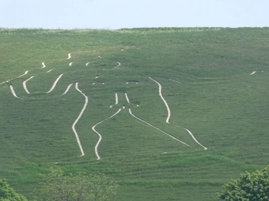
I couldn't resist posting this one, from near me:

I like to think it shouldn't be travelled after dark...
I like to think it shouldn't be travelled after dark...
Peripart
Antediluvian
- Joined
- Aug 1, 2005
- Messages
- 6,733
I wonder if that's where Eric Cantona got his ideas about seagulls?Did you see the little fortune-telling booth?
Someone I know rented that for a while and made a killing. Superstitious business people would ask her advice in no doubt the obliquest terms possibleand she'd reply with 'A white horse may leap over a red fence but refuse a flowering hedge' (or summat, I dunno) and the client'd be wide-eyed with interest.
They'd often be back a week or two later with a big tip.")
maximus otter
Recovering policeman
- Joined
- Aug 9, 2001
- Messages
- 13,944
Dead Womans Lane is still there, but now appears to be a 'no through road'....indeed, a 'dead end'.
It's not that far from me, only a couple of miles, I might go and investigate.
(EDIT - google maps streetview shows it to be a muddy lane that the google car doing photographs clearly decided was non-navigable, but I think my 4WD will cope.)
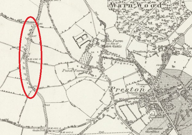
View attachment 50710
A bit more armchair detective-ing suggests that the Black Death victims were buried at Wayley Close:
"...the fields of Wayley Wick and Wayley Close. In 1845 the manorial documents stated that these two closes were enclosed with Woodclose. The 1818 Enclosure map notes that they straddled a lane then known as Wayley Green Lane, now called Tatmore Hills Lane."
https://www.theredlionpreston.co.uk/historical-places-of-interest/

Dead Woman's Lane lower left; Tatmore Hills Lane upper left
Some tourist info for the area, inc. a map:
https://www.prestonvillageherts.com/wp-content/uploads/2019/06/Preston_walk.pdf
maximus otter
Last edited:
Brilliant, thanks MO I couldn't quite remember where the cottage was but reading the link it was Sootfield Green.
OS 6" to the mile, surveyed 1878-1881
"Dead Womans Lane, believed to be so named because the plague victims of Welei were buried in the adjacent field 'Wayley Close'.
The most credible cause for the desertion of Welei, which disappears from historical records at around the time of 1348/9 is that it became another victim of the Black Death which was scything it's way through the population of the country at that time. Nearby Hitchin and Codicote were well documented as being decimated by the plague, and prompted a BBC documentary "Christina - a Medieval Life" which focussed on life and death in Codicote.
Although history suggests that plague victims were buried normally in consecrated ground, this is unlikely to be the case at Welei. The locals were a) renowned as pagan worshippers and b) the nearest consecrated ground was a good way off. It is unlikely that locals, who were overtaken by grief and debilitating illness, would have had the desire or strength to cart the corpses of their families and neighbours to Ippollitts or Hitchin for interment. Easier by far to bury them nearby in the adjacent field 'Wayley Close' "
https://www.geocaching.com/geocache/GC5Y6BJ_welei-dead-womans-lane
maximus otter
I was working there in the early 2000s I think and it was more of a farm track than a road I seem to recall. It was very much 'out in the wilds' for Hertfordshire I thought and must have been pretty isolated in the middle ages. You can see why they were said to be Pagan.Dead Womans Lane is still there, but now appears to be a 'no through road'....indeed, a 'dead end'.
It's not that far from me, only a couple of miles, I might go and investigate.
(EDIT - google maps streetview shows it to be a muddy lane that the google car doing photographs clearly decided was non-navigable, but I think my 4WD will cope.)
View attachment 50710
escargot
Disciple of Marduk
- Joined
- Aug 24, 2001
- Messages
- 43,323
- Location
- HM The Tower of London
Came across this list of Cheshire street names, neatly alphabetised -
Badgers Close, Ellesmere Port
Brains Lane, Tarporley
Corkscrew Lane, Chester
Coronation Street, Crewe
Cow Lane, Frodsham
Filter Bed Way, Sandbach
First Dig Lane, Nantwich
Fol Hollow, Congleton
Hooker Street, Northwich
Love Street, Chester
Lumpy Street, Congleton
Maggoty Lane, Macclesfield
Oddfellows Passage, Middlewich
Offal Pit Lane, Frodsham
Paradise, Chester
Pudding Lane, Tarporley
Rabbit Burrows Lane, Tarporley
Second Dig Lane, Nantwich
Slaughter Hill, Haslington
Sweettooth Lane, Sandbach
I know quite a few of those. They're not the daftest though.
I don't see Badcocks Lane or any other variation of 'Cock', or Darkie Meadow, for a start.
Dick Turpin
Justified & Ancient
- Joined
- Mar 28, 2018
- Messages
- 1,027
In the City of London running from the Mansion house to St Pauls, there is a street called Cheapside. Chepe being an olde English word for market.Came across this list of Cheshire street names, neatly alphabetised -
Badgers Close, Ellesmere Port
Brains Lane, Tarporley
Corkscrew Lane, Chester
Coronation Street, Crewe
Cow Lane, Frodsham
Filter Bed Way, Sandbach
First Dig Lane, Nantwich
Fol Hollow, Congleton
Hooker Street, Northwich
Love Street, Chester
Lumpy Street, Congleton
Maggoty Lane, Macclesfield
Oddfellows Passage, Middlewich
Offal Pit Lane, Frodsham
Paradise, Chester
Pudding Lane, Tarporley
Rabbit Burrows Lane, Tarporley
Second Dig Lane, Nantwich
Slaughter Hill, Haslington
Sweettooth Lane, Sandbach
I know quite a few of those. They're not the daftest though.
I don't see Badcocks Lane or any other variation of 'Cock', or Darkie Meadow, for a start.
Many of the side streets off Cheapside are still named after the goods that were once sold there. Including Milk Street, Bread Street, Honey Street, Wood Street etc.
According to some sources there was even a Cu*t lane running off of Cheapside………….Hmmm Wonder what was sold there lol
maximus otter
Recovering policeman
- Joined
- Aug 9, 2001
- Messages
- 13,944
According to some sources there was even a Cu*t lane running off of Cheapside………….Hmmm Wonder what was sold there lol
https://en.m.wikipedia.org/wiki/Gropecunt_Lane
maximus otter
- Joined
- Mar 9, 2002
- Messages
- 13,692
Nelson St in Bristol was previously Gropec*nt Lane, until the early 1700s: at that point it was just outside the city wall. It became Grape St when the fruit market was relocated there, then Nelson St after Trafalgar.
This is very, very rarely mentioned in school local history lessons. Also worth remembering that back then "c*nt" wasn't particularly offensive. Blasphemy was still the big taboo until the Reformation when the emphasis started to shift.
This is very, very rarely mentioned in school local history lessons. Also worth remembering that back then "c*nt" wasn't particularly offensive. Blasphemy was still the big taboo until the Reformation when the emphasis started to shift.
I have posted elsewhere a link to the youtube of Jack Hargreaves explaining how we have villages which share a 'surname' (if you like) - these villages grew up around packets of land that ascend from a stretch of river, following a tributary up a valley, with each area belonging to the next family member in order of ancestry, so the best piece of land is by the river itself, the next best piece of land borders that but further up the valley, and so on.
So, when 'old man Chadwick' (eg) carks it, his son would move down from his part of the valley and take over his fathers land, the grandson would move down into the sons plot, and so on.
Each of these plots would be named after their original settlers, so you would have 'Chadwick' on the rivers edge, then next up the valley would be (eg) 'Barney Chadwick', and then 'Murray Chadwick' etc etc.
So if you ever see one of those roadsigns directing you towards 'The Marshalls' (eg) then it is pointing out one of these ancient collections of villages near a river.
(and before posting this just now I noticed a typo which I had to correct which made me chuckle - I had called him Jack Duckworth by mistake)
Floyd
Antediluvian
- Joined
- Apr 2, 2019
- Messages
- 7,851
Trev lived there.According to some sources there was even a Cu*t lane running off of Cheapside………….Hmmm Wonder what was sold there lol
Nah it's all just flimsy rumours.Trev lived there.
Tunn11
Justified & Ancient
- Joined
- Nov 23, 2005
- Messages
- 2,236
- Location
- Under the highest tree top in Kent
Village names round ‘ereabouts include: Pratts Bottom – named for Thomas Prat and being at the bottom of Rushmore Hill. It is alleged that some residents started pronouncing it Prahs Botham and the local angling club then called themselves the Pratt’s Bottom Danglers.
It’s a bit like the London District of Saint Reatham. - Oh sorry Streatham.
There is also a Badgers Mount, I can only guess at the origin of that.
Street names include Hitchen Hatch Lane, World’s End Lane and Witches Lane.
It’s a bit like the London District of Saint Reatham. - Oh sorry Streatham.
There is also a Badgers Mount, I can only guess at the origin of that.
Street names include Hitchen Hatch Lane, World’s End Lane and Witches Lane.
CarlosTheDJ
Antediluvian
- Joined
- Feb 1, 2007
- Messages
- 7,001
- Location
- Pebble Mill
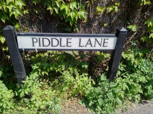
There's a Slugwash Lane not far from here, and I often ramble around Poverty Bottom.
I never seem to be far away from there....and I often ramble around Poverty Bottom.
Bad Bungle
Tutti but not Frutti.
- Joined
- Oct 13, 2018
- Messages
- 4,131
- Location
- The Chilterns
Not much effort seems to have been spent in the naming of villages around me - Stone, Ford, Marsh (may be surnames). We do have a Gibraltar (apparently built on a rock say the Geologists). Nettlebed (pop~800) first recorded in the 13th Century (Netelbedde), however does mean a place overgrown with nettles.
Frideswide
Fortea Morgana :) PeteByrdie certificated Princess
- Joined
- Jul 14, 2014
- Messages
- 16,310
- Location
- An Eochair

There is an Egypt not too far from me, the name may have been associated with Romany Gypsies who apparently often visited the area.Not much effort seems to have been spent in the naming of villages around me - Stone, Ford, Marsh (may be surnames). We do have a Gibraltar (apparently built on a rock say the Geologists). Nettlebed (pop~800) first recorded in the 13th Century (Netelbedde), however does mean a place overgrown with nettles.