• We have updated the guidelines regarding posting political content: please see the stickied thread on Website Issues.

Phantom (Apocryphal; Transient) Islands

Determining latitude has been possible with a high degree of accuracy for centuries. Longitude is different. It required very accurate clocks. Until the development of the ship's chronometer longitude determination was largely guesswork. So I suspect some of the phantom islands were already identified, and the 'new discoverer' was just in error by several degrees of longitude.
 
Before I retired I worked for a government land agency, doing GIS work. I was creating a new annotation layer for some digital maps of a Wilderness Area when I noticed some fairly large and prominent features did not have a name. By policy, the Board of Geographical Names does not assign names to features inside designated Wilderness Areas unless there is a compelling reason. Being a short timer and in a whimsical mood, I started naming some unnamed lakes, peaks, et al. A lake received my wife's name, a distinctive mountain peak after my daughter, etc. My dog even had a meadow named after her. All completely unofficial and without any authority on my part.
I fully expected my efforts to be discovered and discarded after I was gone. To my surprise a few years later a new map of the area was released, and lo and behold, my names were printed on the map. My little piece of immortality.
 
Vincent Gaddis' book, Invisible Horizons, is on it's way. It has the story of many of these phantom islands. OT, but it also has the story of the Ivan Vassily, a ship that was seemingly born under an evil star. I linked to it in another thread.
 
Wasn't there a vanishing island in the Irish sea? A plane flew over it. South of the Isle of Man.


I can't find anything about it. I remember the story a light aircraft with two people were flying from the midlands to Belfast,( I think), and flew over it. They described the terrain and flew over it for several minutes.
 
Wasn't there a vanishing island in the Irish sea? A plane flew over it. South of the Isle of Man.
Very unlikely.The Irish Sea is not some remote stretch of ocean that rarely sees a passing vessel - it's regularly used by merchant ships, the military (including submarines), fishing boats, assorted work-boats, ferries, and pleasure craft of all sizes.

There are the major ports of Liverpool, Holyhead, Dublin and Belfast surrounding the area, as well as the ports of the Isle of Man itself, and Barrow-in-Furness and Fleetwood on the English coast.

Any more info on the alleged 'plane'?
 
I can't find anything about it. I remember the story a light aircraft with two people were flying from the midlands to Belfast,( I think), and flew over it. They described the terrain and flew over it for several minutes.
It would only take a few minutes to fly over the Isle of Man itself! :D
 
Very unlikely.The Irish Sea is not some remote stretch of ocean that rarely sees a passing vessel - it's regularly used by merchant ships, the military (including submarines), fishing boats, assorted work-boats, ferries, and pleasure craft of all sizes.

There are the major ports of Liverpool, Holyhead, Dublin and Belfast surrounding the area, as well as the ports of the Isle of Man itself, and Barrow-in-Furness and Fleetwood on the English coast.

Any more info on the alleged 'plane'?

I think that was the point of the story, the size of the island was too big to fit. The plane as I recall just your usual Cessna-type plane. I'm familiar with the ports on both sides of the Irish sea thanks.
 
The island of Bermeja in the Gulf of Mexico is a great one. It appeared on maps in the 16th century and its non- existance was only noted in 1997! Even better, there is a conspiracy theory that it was destroyed by the CIA to grab more territory for oil.
 
I'm suggesting the pilot got his position wrong, and actually flew over IoM while thinking he was elsewhere!
And the Irish Sea is noted for being frequently foggy. There is some interesting weather there right now - winds are southerly on the east side, and northerly on the west side, with a band of calm or variable winds in between.

It's only about 50 miles between Anglesey and IoM.

I only had the vaguest recollection of the story, but the pilot was certain he was well south of the Isle of Man and would have been South West of HolyHead.
 
I can't find anything about it. I remember the story a light aircraft with two people were flying from the midlands to Belfast,( I think), and flew over it. They described the terrain and flew over it for several minutes.
And later, N_F added "..the pilot was certain he was well south of the Isle of Man and would have been South West of HolyHead."

I have to ask, what was he doing there? Assuming the 'midlands' is Birmingham, a direct course to Belfast would pass close SW of IoM, well north of Holyhead. I'm not familiar with traffic routeing for light aircraft, but SW of Holyhead seems well out of the way.

Given all the air and sea traffic that regularly crosses the Irish Sea without reporting any phantom islands, I don't think a single sketchy report, without any more information, is worth worrying about. And in clear weather, such an island should even have been seen from land in the 50 mile gap between Man and Mona (Anglesey).
 
Given all the air and sea traffic that regularly crosses the Irish Sea without reporting any phantom islands, I don't think a single sketchy report, without any more information, is worth worrying about. And in clear weather, such an island should even have been seen from land in the 50 mile gap between Man and Mona (Anglesey).
Well if anyone else remembers this story and perhaps has the full details rather than half-remembered ones I would be very interested to hear it. It sounds like proper mysterious stuff whatever the truth of the matter.
 
Wasn't there a vanishing island in the Irish sea? A plane flew over it. South of the Isle of Man.
When I saw this post, I thought of Hy Brazil, but I had the wrong location. Hy Brazil is supposedly off the west coast of Ireland. Dr. Bob Curran goes into this island quite a bit in his fascinating book Lost Realms, Forgotten Lands.
 
The island of Sodor. Toot, toot!
Cute. Not quite what I had in mind however. Has anyone heard of Antilla? Vincent Gaddis goes into a bit of history when he told of the Portuguese voyage from the late 700's if memory serves, who were fleeing from the Moorish conquest of Spain and Portugal. Setting sail for the Azores they were blown off course far to the northwest and disappeared from the picture.

Advance the calendar to the fourteenth century and a Portuguese (or Spanish) ship was blown off-course far to the northwest and they came across an island with seven villages where the residents spoke Portuguese and were asking about the Moorish invasion of Spain. There were many gold items on the island. The sailors were able to repair their ship and return to their homes.

Gaddis called this island Mayda or Asmayda and I have heard other very similar accounts which called the island Antilla. He suggests that this might be the source for the legend of El Dorado, as when the sailors were gathering sand from the harbor, they noticed many flecks of gold in it and concluded that this must be the source of the island's gold.

Later accounts have the area of the ocean where the island was supposed to be as subject to many earthquakes, some of them quite severe, and Gaddis theorizes that this might be the reason the island was never found after the sailors returned.

It makes a nice story anyway. Who knows? There might even be a bit of truth to it.
 
Bishop Pontoppidan of Bergen Norway wrote in 1755 that islands that
appear and disappear suddenly in Northern seas are certainly Kraken,
a fully grown Kracken was said to be a mile and a half long and often
mistaken for a small inland,
On a more up to date note I wounder how long ago the plane incident took place
it seems very unlikely and pilot undertaking a flight with a over water leg would not
have at least a portable gps even in the most basic aircraft and it would be strange
if they could not tell they were over the IOM, I used to fly in a Piper Tri-Pacer a 1950's
aircraft in the 1970's no gps but pretty sure we would know if we were over something as big
as the iom by using maps and radio beacons even then.
 
Had to think about that acronym 'iom', but then I think I figured it out. Isle of Man, right?
 
Is there anything about the Atlantic floor topography which suggests there might have been an island out there?
After checking on google maps, there doesn't seem to be anything, no. Rockall can't be it because of both the location (quite a ways north of where Hy Brazil is supposed to be) and the fact that it is there. It doesn't disappear.
 
Rockall can't be it because of both the location (quite a ways north of where Hy Brazil is supposed to be) and the fact that it is there. It doesn't disappear.
I've seen Rockall disappear! We were trying to sail round it, but it disappeared - in the fog!
 
If you look further out, where the continental plates join in the middle of the Atlantic, that's where appearing/disappearing islands are most likely to be. Volcanic and seismic activity where the plates join could throw up an island and later on, destroy it.
 
If you look further out, where the continental plates join in the middle of the Atlantic, that's where appearing/disappearing islands are most likely to be. Volcanic and seismic activity where the plates join could throw up an island and later on, destroy it.
Quite so. At the juncture of the North American Plate, the Eurasian Plate and and the African Plate are the Azores. I used to think of the Azores as a prime candidate for Atlantis, but have since changed my thinking.
 
I wouldn't dismiss The Azores as a remnant of Atlantis just yet. There is evidence of ancient human occupation there - thousands of years before the Portuguese officially discovered them:

http://portuguese-american-journal....art-found-in-caves-on-terceira-island-azores/

Furthermore, given the far lower sea level of say 10,000 BC and the possibilities inherent in tectonic upheaval, the Azores may well have constituted one far larger land mass, as did the Canaries and Madeira.
That article certainly gives a different perspective on it. The research seems to just be getting started and I'd certainly like to see what becomes of it.

What changed my original thinking on the Azores was the geological claim that the area around the Azores has been underwater for too long for it to be Atlantis.
 
The title of a thread in another subforum on this site made me think of these: the Aurora Islands. These were supposedly in the South Atlantic off the Argentine coast and were very likely either the Shag Rocks or the Falklands.

Admittedly, it is a trifle hard to see how the Shag Rocks could be mistaken for islands as the total area is 49 acres (20 hectares)
 
"it is a trifle hard to see how the Shag Rocks could be mistaken for islands as the total area is 49 acres (20 hectares)"

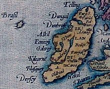
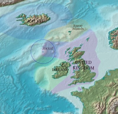
The reputed size of such 'phantom islands' varies a lot. The (in)famous Hy-Brasil, supposedly containing a castle and occupied by strange fauna, including huge black rabbits, was relegated to the name "Brasil Rock" on some later charts and, given its purported location to the west of the British Isles, may well have been a misidentification of the diminutive Rockall.

Hy_Brasil.jpg

Rockall_EEZ.jpg
 
"it is a trifle hard to see how the Shag Rocks could be mistaken for islands as the total area is 49 acres (20 hectares)"

The reputed size of such 'phantom islands' varies a lot. The (in)famous Hy-Brasil, supposedly containing a castle and occupied by strange fauna, including huge black rabbits, was relegated to the name "Brasil Rock" on some later charts and, given its purported location to the west of the British Isles, may well have been a misidentification of the diminutive Rockall.

View attachment 4170

View attachment 4171
Your point, good sir, is well-taken. The size of islands is sometimes hard to determine especially from a distance. And some of them are no doubt, mirages. Saxemberg, mentioned earlier in this thread may well be an example of this.

On the other hand, the chief navigation problem for seamen has always been longitude, not latitude, and Rockall is quite a ways almost due north of the reputed location of Hy Brazil, and this makes it a bit less likely, in my humble opinion, that Hy Brazil is simply confused version of Rockall. Not impossible, just less likely.
 
Back
Top