• We have updated the guidelines regarding posting political content: please see the stickied thread on Website Issues.

'That Man's Name Is...'

...and I can't believe that they would have tried to persuade him home at 3pm, however dark it may have been getting...

Three in the afternoon is the time the boy is supposed to have left home. The other events described clearly took place after this, but there's no evidence to suggest that they did so soon after this, rather than at some time in the course of the evening. The written account suggests that the tram crew's advice was given later in the evening.

The use of the term 'schoolboy' might sound a bit odd now - but it's possible that it's just a word used as an indicator of age, in an era when the idea of a 'teenager' did not really yet exist. (I'd suggest, 'child', 'schoolboy', 'youth', 'young man' might be the sequence used by the press of this period - with some class based interchanging between 'schoolboy' and 'youth'.)
 
Last edited:
Just checked Whitaker's book.

Although, apart from 'night', no specific time is given for the tram crew's advice to the boy (in D = see post #27 above), the clear inference is that it's significantly later in the day than his initial absence from home.

Another very relevant detail which I'd forgotten, is that they try to persuade the boy, not to alight at the terminus, but to go back to town with them, as, owing to the thick fog, the service was being suspended.
 
Ah, thanks Spook, that all makes much more sense. I'd got it into my head that the boy (youth/teenager) got onto the tram as soon as he left home, on an outward journey.
 
I realised, in the early hours of this morning, what the resonance was that's been nibbling at the corner of my mind: The boy with the odd message; the tram; the fog; the inferred, but never elucidated, suggestion that something else is going on; the slightly surreal atmosphere of it all...

Anyone else feel like they've stumbled across an (allegedly) real life Robert Aickman story.
 
The use of the term 'schoolboy' might sound a bit odd now - but it's possible that it's just a word used as an indicator of age, in an era when the idea of a 'teenager' did not really yet exist.
He wouldn't be called a teenager now either given he was only 11!
 
The details of the story give me the impression that the boy was meeting someone he was acquainted with. If he were informed of the suspension of tram service, why did he insist on getting off unless he meant to not go back by tram that day?
 
I’m in Chorlton right now! I’ve lived here 15 years and never heard this story before. The area is now Sale Water Park. Out of interest, does anybody know where the boy used to live?
 
The details of the story give me the impression that the boy was meeting someone he was acquainted with. If he were informed of the suspension of tram service, why did he insist on getting off unless he meant to not go back by tram that day?

The murder locus looks like the kind of place where a couple of adventurous lads might go to play undisturbed. It’s quite near Chorlton, but the presence of the sewage beds would make it an undesirable place of resort for adults. It’s enclosed to the north and south by the Chorlton Brook and the Mersey respectively, so there would be no through traffic.

Unfortunately, the same characteristics render it a suitable site to which to lure a victim, if your aim is enjoyment of a...different kind.

maximus otter
 
I found this summary of the incident at Google Books. It includes some points I don't think had been mentioned before.

ODonnell-1928-12-02.jpg

SOURCE: Grim Almanac of Manchester, by Michala Hulme. The History Press, 2015
https://books.google.com/books?id=F...ge&q="William Francis O'Donnell" 1928&f=false
 
Out of interest, does anybody know where the boy used to live?
He lived in a big house on Wilbraham Road. It's only about 1/2 a mile from where he was found. (He didn't 'head for Chorlton', he lived there. The alleged tram sighting seems a bit a bit of a red herring for that reason as trams go down main roads, and he probably headed away from the main road to get to the meadows).
 
Last edited:

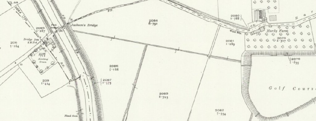
The Bridge Inn, by Jackson's Bridge over the Mersey, and the local golf course off to the east:

Jackson-s-Bridge-golf-course-Chorlton-Fortean.jpg


Also, my Googling revealed this:

"...it was Buxton's Guide, a masterpiece. "

During the 19th century the valley's meadows - particularly those around the Jackson's Boat Inn near Chorlton Golf Course - were regularly visited by botanists.

Among the first people to study the valley's vast array of plant life were groups formed by working-class people who bandied together through their shared love of botany. One of the prime movers and shakers was Richard Buxton, an impoverished shoemaker from Ancoats who taught himself botany. In 1849 he published Buxton's Guide, a book about the flora found in Chorlton, Didsbury, Northenden and Sale."

https://www.manchestereveningnews.co.uk/news/local-news/how-green-was-our-valley-1002759

maximus otter
 
The locus today:

Jackson-s-Bridge-Rifle-Road-Chorlton-Fortean-arrowed.jpg


Rifle Road, Chorlton, Sale ends at what is still the Jackson's Boat pub.

Jackson's Bridge is still there, too. Both the footpath by the pub, and the motorway slip road off Junction 6 of the M60 just to the south, feed into Hardy Lane, Chorlton.

Jackson-s-Boat-pub-bridge-Fortean.jpg


The pub and footbridge:

Rifle Rd
Sale
Cheshire
M33 2LX

The pub's own website.

maximus otter
 
Last edited:
The filter beds mentioned in other accounts were I think situated in the treeless area in the very top left of the aerial image in Maximus Otter's post; the pump house somewhere this side of the nearest corner.
 
I’m in Chorlton right now! I’ve lived here 15 years and never heard this story before. The area is now Sale Water Park. Out of interest, does anybody know where the boy used to live?

Okay - you are now designated point man. But if, of a darkening afternoon, you see a young lad dressed like Liberace beckoning you into the woods...run away very, very quickly.
 
The filter beds mentioned in other accounts were I think situated in the treeless area in the very top left of the aerial image in Maximus Otter's post; the pump house somewhere this side of the nearest corner.

Jackson-s-Inn-and-filter-beds-Fortean-arrowed.jpg


maximus otter
 
The man who found the body deposition site had a fucking good drive on him, if he was looking for a lost golf ball. I've just checked, and the distance from the centre of Jackson's Bridge over the Mersey, to the very nearest point of the golf course off to the east, is 499.7 yards.

"...the median driving distance is 219.55 yards. Other club distances of note: the median 3-wood goes 186.89 yards, 7-iron clocks in at 133.48 yards and pitching wedge at a 73.97 mark."

https://www.golfdigest.com/story/ho...ly-hit-it-new-distance-data-will-surprise-you

Edited (1135) to add: Also, it presupposes that the golfer went to the extreme western end of the golf course, then drove his ball a mighty whack farther west for some reason.

Edited further (1203): @EnolaGaia's post makes it clear that the golfer was playing golf near to the Jackson's Boat Inn, not at the nearest golf course that I could find. D'oh!

maximus otter
 
Last edited:
...Edited further (1203): @EnolaGaia's post makes it clear that the golfer was playing golf near to the Jackson's Boat Inn, not at the nearest golf course that I could find. D'oh!...

Yes, I took it as meaning that the pub was the nearest easily recognisable waymarker - giving the 'near to' definition a fairly considerable leeway. (Pubs seem to have been a recognised datum for orientation even in official documents; I've got a very pretty AA London route map from the 1930's on my wall which has very many of London's pubs marked in bold - rather than being information regarding where to stop your journey for a pint, I've always assumed this was because they were used by people to mark out routes in the days before road numbering.)

Edit: Actually, seems the road numbering system was already in place at this time (and, dummy that I am, there are in fact numbers on that map - but much less obvious than the pub names). However, given the pubs named appear to be those near junctions and at crossroads, it does look like they were included for orientation.
 
Last edited:
Back
Top