• We have updated the guidelines regarding posting political content: please see the stickied thread on Website Issues.

The Harrow Way (Ancient British Green Road)

AnonyJ

Captainess Sensible
Joined
Nov 1, 2015
Messages
1,916
Location
Having-a-nice-cup-of-tea-and-a-sit-down-shire
I couldn't find any mention of this ancient British 'road' on here, but please merge me in if I am mistaken :)

I'm currently enjoying an in-depth interest with ancient Britain and onwards into the Anglo-Saxon era, when my area became Wessex, then part of the new 'England'. There's some excellent history audio books around!

I'd heard of Watling Street and Fosse Way but then came across mention of a much earlier route, The Harrow Way. It ran from what is now Seaton, Devon to Dover, Kent in a curved arc, the modern A30 road seems to follow it fairly closely until the Farnham area. Wikipedia https://en.wikipedia.org/wiki/Harrow_Way tells me:

"The Harrow Way (also spelled as "Harroway") is another name for the "Old Way", an ancient trackway in the south of England, dated by archaeological finds to 600–450 BC, but probably in existence since the Stone Age.The Old Way ran from Seaton in Devon to Dover, Kent. Later the eastern part of the Harrow Way become known as the Pilgrims Way, following the canonisation of Thomas Beckett and the establishment of a shrine in Canterbury, Kent. This pilgrimage route ran from Winchester, Hampshire, via Farnham, Surrey, to Canterbury Kent. The western section of the Harrow Way ends in Farnham, the eastern in Dover.

The name may derive from herewag, a military road, or har, ancient (as in hoary) way, or heargway, the road to the shrine (perhaps Stonehenge). It is sometimes described as the 'oldest road in Britain' and is possibly associated with ancient tin trading."

I've now become very interested as I live very close to the western A30 road, within 30 seconds' walk! I have always been under the impression that where my home is was post-war spare agricultural land, and I'm probably right, but it also turns out there is 2,500 year old road passing by very close by. I wish I could do metal detecting!

This is all very interesting to me, but I'm not sure how this will grab my dear Fortean friends here except for this delicious bit of synchronicity:

@Yithian posted here https://forums.forteana.org/index.p...ou-onto-the-fortean.46756/page-2#post-1949059

That's Antony Dacres Hippisley Coxe.

Is he related to R Hippisley Coxe?

Yes, I've noticed the lack of final 'e'.

View attachment 24862

In reply to my post about spooky books. It turns out that The Harrow Way has a significant mention in that actual book!


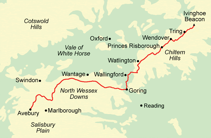
Anglo-Saxon Chronicle - Locations with Old Way

Adam37 / CC BY-SA (https://creativecommons.org/licenses/by-sa/3.0)
 
Interesting. I wonder if there are any good books about these green ways?

My Anglo Saxon is a bit rusty (no I'm not that old, just studied it at uni) but my money is on it being here-waeg and the "here" (pronounced "herra") means "army". The other ones could be correct, too. But I think it would be most likely to be Army Way.

Heard an interesting talk by someone from these people:

https://britishpilgrimage.org/

Scroll down to bottom of page for some Ways.

Seems like a distant dream at the moment, but maybe nice to fantasise about going on a little walk when this crap is all over. That's what I'm doing, anyway!

I'd love to know more about these tracks and where the lost ones might be... And whether they coincide with any woo, like linking important barrows, or stone circles, or what..?
 
Wikipedia on herepaths.

I seem to remember the Ridgeway being referred to as a herepath. (I set out to hike it once, but my feet blew up with enormous blisters on Day One. Some day...)

ridgeway-map.gif


I also recollect that in Anglo-Saxon, a here was a band of 35 warriors or more. Why 35? I am failed by whatever serves me as a brain.

maximus otter
Not sure but they had a frightening number of words for "army"... Actually more than I can recall. Like Old Icelandic had a ridiculous number of different words for "horse".
 
Prehistory is /really/ interesting. Not my period but I am still enthralled!

I can recommend anything by Gary Lock, not just because he's a dear friend and professional colleague. This is a summary of a talk he gave a bit back....

http://www.archaeologyinmarlow.org....eritus-professor-gary-lock-oxford-university/

I thought it might be of interest becuase it's the same idea. Route is there. Hill Forts are there. How much is that serendipity, how much is causal connection (and which direction), and how much is independent need for the site without a caulsl link?
 
That's a nice piece of crop circle artwork, but it doesn't resemble the COVID-19 virus.

Though, now that you've brought it up ... A coronavirus figure would lend itself to being rendered as a crop circle installation.
 
Wikipedia on herepaths.

I seem to remember the Ridgeway being referred to as a herepath. (I set out to hike it once, but my feet blew up with enormous blisters on Day One. Some day...)

ridgeway-map.gif


I also recollect that in Anglo-Saxon, a here was a band of 35 warriors or more. Why 35? I am failed by whatever serves me as a brain.

maximus otter

I did a little bit of searching and found this:

<<For example, in the fragmentary poem of Fight at Finnsburh, an army is mentioned to only have 60 men. Similarly, some modern historians like Pete Sawyer have taken the etymological route in defining what actually constituted an ‘army’ – with one of the Laws of King Ine of Wessex (issued in 694 AD), defining an here or army as consisting of only 35 men!>> Here: https://www.realmofhistory.com/2016/09/17/10-facts-anglo-saxons-warriors/

Speculating now: a leader who can raise an "army" of 35 men makes a unit of 36.

36 is a useful number as it can be arranged:

1 rank or group of 36 warriors (obviously)
2 ranks or groups of 18
3 ranks or groups of 12
4 ranks of or groups of 9
6 ranks or groups of 6

And, although less likely in combat, all the inverses (18 pairs, 12 units of 3, etc.)

(Also, 5 units of 7 with the leader standing separately?)

That is, like the old predecimal currency with 12 pennies in a shilling, 36 men was a versatile number for a small army, easy to split into various equal sized sub units.
 
As per @Yithian's post on another thread, this one has several honorouble mentions elsewhere online

View attachment 25316

As has this

View attachment 25317

I'd also love to hear of any more!

Got my copy of the Green Roads of England today in the post. I assumed there wouldn't be much to investigate in my locality (Chilterns) - hah, it will take me a year to join up the roads between the Ridgeway, Akeman Street, Grims Ditch, Cholesbury Camp, the Kimbles etc.
 
That's a nice piece of crop circle artwork, but it doesn't resemble the COVID-19 virus.

Though, now that you've brought it up ... A coronavirus figure would lend itself to being rendered as a crop circle installation.
LOL. Yeah I shoulda cropped the screen shot. There doesn't seem to be a website in existence that doesn't have a reference to c19 on its front page.
 
Does anyone know of a green roads / ancient trackways for Scotland?

Different terrain, different culture, different land rights... but still!
 
It would make sense that the old drovers' roads might coincide as they were probably usually the most serviceable roads around..? (Built over existing routes, sometimes?)

A while ago I was told about one of those coffin routes up in the Lake District as I was doing a talk about the flax industry in 19thC Lakes, in Cumbria, and the locals started telling me where the disused flax retting ponds were hiding, and someone mentioned the corpse roads... I think they said one of the forgotten retting ponds was on or close to a 'coffin road' and I had to go look it up afterwards. I fully meant to get up there this spring to investigate!

https://en.wikipedia.org/wiki/Corpse_road
 
Last edited:
I did a little bit of searching and found this:

<<For example, in the fragmentary poem of Fight at Finnsburh, an army is mentioned to only have 60 men. Similarly, some modern historians like Pete Sawyer have taken the etymological route in defining what actually constituted an ‘army’ – with one of the Laws of King Ine of Wessex (issued in 694 AD), defining an here or army as consisting of only 35 men!>> Here: https://www.realmofhistory.com/2016/09/17/10-facts-anglo-saxons-warriors/

Speculating now: a leader who can raise an "army" of 35 men makes a unit of 36.

36 is a useful number as it can be arranged:

1 rank or group of 36 warriors (obviously)
2 ranks or groups of 18
3 ranks or groups of 12
4 ranks of or groups of 9
6 ranks or groups of 6

And, although less likely in combat, all the inverses (18 pairs, 12 units of 3, etc.)

(Also, 5 units of 7 with the leader standing separately?)

That is, like the old predecimal currency with 12 pennies in a shilling, 36 men was a versatile number for a small army, easy to split into various equal sized sub units.
I can't remember which word for 'army' (or maybe several) are used in the original, there, but it could also be that the word being translated as 'army' might just as well be translated as 'batallion' or 'unit' or 'warband'... It's always gonna be problematic if read in Modern English as you're at the mercy of the translator.

But here's "here" definition in the definitive Anglo Saxon dictionary:

http://bosworth.ff.cuni.cz/finder/3/here

and here is "fyrd":

http://bosworth.ff.cuni.cz/finder/3/fyrd

There are other words I forget including, no doubt, a tonne of poetical words or kennings that may have been literary-use only kinda thing.

Also worth bearing in mind that there may be no hard and fast rules as until the 10thC, England was a series of different kingdoms with slightly different variants of the language, and maybe also slightly different social structures. In other words: the Northumbrian king's idea of a decent sized retinue or army might not have been the same as the Wessex king's...
 
Re. green paths, trackways, there's a very Fortean post appeared today (28/12/21) on the FB Group "Ridegway and Ancient Tracks of Britain". Redacted, but here's the beginning to give a sense of it. To see what the person saw, you'll need to join the group, but may be worth it for those who are interested in ancient trackways...

It's a public group, not a closed one:

https://www.facebook.com/groups/815883248934810/

ETA: Hadn't got through the hundreds of comments but see someone else has gone on there and linked the poster here so hopefully he will join us.

Deep breath... I am going to talk about an experience I had about 20 years ago on the Icknield Way which is as clear today as it was then. I have only told a couple of close friends and I am genuinely convinced that what I saw was real...
So, I have spent most of my life (including being born) on the Bedfordshire chalk downlands. I am an ecologist, wildlife artist and writer on wildlife and landscapes. I am also very sensitive to nature and landscapes, intuitive and I believe that there is still a lot more around us then that which can be explained by science...
One evening I was walking my dog among a stretch of the Icknield Way between Hitchin (Pirton) and along the crest of Deacon and Pegsdon Hills following the Beds/Herts boundary. I know the area very well and was a volunteer warden on Pegsdon Hills Nature Reserve. It was mid May, warm, still and sunny. Part of the stretch forms a 'green lane' about 20ft wide with with thick hedges each side and, one on side was a ditch about 10 - 12ft feet wide and about 4 - 5ft deep, overhung with tangled hawthorn, blackthorn, wild clematis and with mature ash trees overhead.
There were no other people around but as I climbed up the hill I could smell and see smoke.
I came across several people who were camping in the ditch. I then realised with absolute astonishment that they looked really 'odd'...
 
Re. green paths, trackways, there's a very Fortean post appeared today (28/12/21) on the FB Group "Ridegway and Ancient Tracks of Britain". Redacted, but here's the beginning to give a sense of it. To see what the person saw, you'll need to join the group, but may be worth it for those who are interested in ancient trackways...

It's a public group, not a closed one:

https://www.facebook.com/groups/815883248934810/

ETA: Hadn't got through the hundreds of comments but see someone else has gone on there and linked the poster here so hopefully he will join us..
Spookily enough Facebook suggested this as a group i might be interested in just BEFORE i read this post. And it’s damn right! For once.
 
Got my copy of the Green Roads of England today in the post. I assumed there wouldn't be much to investigate in my locality (Chilterns) - hah, it will take me a year to join up the roads between the Ridgeway, Akeman Street, Grims Ditch, Cholesbury Camp, the Kimbles etc.
Having revisited this thread and deciding The Green Roads of England would be a great book to read over Xmas, I have just been reminded (by myself) that I already have a copy. A mere 45 mins search of the bookcases and I have found it. Now I need local maps and stout walking trainers.
 
Re. green paths, trackways, there's a very Fortean post appeared today (28/12/21) on the FB Group "Ridegway and Ancient Tracks of Britain". Redacted, but here's the beginning to give a sense of it. To see what the person saw, you'll need to join the group, but may be worth it for those who are interested in ancient trackways...

It's a public group, not a closed one:

https://www.facebook.com/groups/815883248934810/

ETA: Hadn't got through the hundreds of comments but see someone else has gone on there and linked the poster here so hopefully he will join us.
Can you print the rest of it for those who have no intention of joining FB?
 
Yes, please! Copy and give us the good part if you can!
(Shh! Some of us don't want to get sucked into FB, er Meta. Or WTF-Book.)
 
I joined Facebook to keep tabs on a closed small group of friends and that has sort of died away. Now only on FB as this year I joined a Metal Detecting site to see what came up on Club digs. However, the photos on 'The Ridgeway and Ancient Tracks of Britain' site have blown me away (nearly 45 years since I last walked extensively on the Ridge). Love Holloways me ! I think I will be spending a long time going through past posts. Great call @Ghost In The Machine
 
Great posts.

Yesterday I travelled by train from Hastings to London Victoria and then down to Cornwall from Paddington. Glued to the window all the way to take in about the landscape and clues to its past (including the White Horse at Westbury). Travelling up from Hastings and across the High Weald AONB was a joy, even on a grey Winter's day. The lines twists and turns through woodland and traditional field patterns as the driver sounds his horn multiple times as footpaths crisscross the line. Not a new housing development in sight. I was itching to get out and go hiking...!

Then down past Reading and you run alongside the old canal system, the gentle rolling hills around Castle Cary, the Somerset levels with distant Glastonbury Tor, the Exe Estuary and Dawlish coastline, the glimpses of Dartmoor.... I could go on (and did!). Just a shame that seemingly everyone under the age of 30 was glued to a screen and not the window for the whole journey. We need young people to understand and value our rural heritage if we are to protect it.
 
Last edited:
Back
Top