• We have updated the guidelines regarding posting political content: please see the stickied thread on Website Issues.
Slightly off subject, but caught a bit on a pap tv prog about a chap who has just released a book about the Japanese getting to America pre-Columbus. The book was called 1421, but can't remember the author. Also there was mention (inc pictures) of an oriental map from the early 15th c. showing most of the continents, which was discovered in the vaults of the British museum or somewhwere.
Anyone shed any light on the murky waters of my ramblings please?
 
Seaweed said:
a chap who has just released a book about the Japanese getting to America pre-Columbus. The book was called 1421, but can't remember the author.

If it's the Chinese you mean, rather than the Japanese, it's Gavin Menzies. Two threads here and here.
 
I count myself as a bit of an authority on the matter, I have never heard of it.

The japanese were never an ocean going race, they did not even have those very usuable junks like the chinese did, the sails were not dissimilar to a viking longships but much more baggy and narrow.
 
JamesM, there is a slight difference between CHINESE and JAPANESE.....
 
That's right - the book 1421 is about the great Chinese expeditions of that particular period.

Quite speculative, though as few contemporary records exist, I believe - haven't read the book myself, so correct me if I'm wrong.
 
Menzies has assembled quite a lot of evidence that the 4 great Chinese "Treasure Fleets" did make very long voyages round the Pacific and Indian oceans and possibly into the Atlantic.

The written record of these voyages is poor because of a well referenced purge of Chinese records by the succeeding Emperor. However there is other evidence including remains; records of beasts such as giraffes, kangaroos (possibly a giant sloth) in the Emperor's zoo; and ambassadors from west Africa being brought back to China.

The interesting thing is that the Chinese knew how to calculate longitude from lunar eclipses. This gives a source for the Portolan charts very different from Graham Hancocks
 
Thats what I thought, your home area could be well mapped.

That gives me a thought - I remember a few years back seeing film of a new island on the icelandic coast being born in fire and smoke, and very impressive it was too. Given the geological instability of the area, are there any aspects of the icelandic geography on the map - different coastlines or islands- that could indicate a date of creation?
 
The delineation of the North coast of Greenland would imply 15th or early 20th century
 
Excellent! A simple method that proves it definitely either is or is not a fake.

Hmmm.
 
Homo Aves said:
JamesM, there is a slight difference between CHINESE and JAPANESE.....

Be nice, it was me, not JamesM that got entirely the wrong country.

Cheers for the links, I shall check them now.
 
Vinlandwatch part 8,000,000:

And the letters to Analytical Chemistry just keep on comin'! Looks like Olin ruffled a few feathers with her last publication (which was the one which kicked off the last round of 'Vinland real?' headlines).

First in the queue to give Olin a good kicking was Robin Clark, whose correspondence appeared a fortnight ago:
Unfortunately her [Olin's] article is based on speculation, lacks logic, and lacks either new information or new insight on the ink, consisting merely of a rewriting of her earlier publications.
Let's recap on who said what. In 1974 Walter and Lucy McCrone found anatase (TiO2) in the ink. Olin speculated that the ink on the map is iron gall, and that the anatase could have got into the ink during its preparation in medieval times.

Alas, Clark notes the particle size of the anatase is consistent with it being manufactured rather than the result of natural processes. And the best evidence is that the ink is carbon black, not iron gall. Furthermore, no trace of anatase has been found in more than 20 other manuscripts made between 700-1500 AD.

But there's more. Published today, this week's spanking is administered by the splendidly named Michael Henchman, who appears to have been a referee for the Olin paper and who advised against publication. He doesn't mince his words:
Throughout, Olin deceives with false logic.
Ouch. Henchman notes that Olin begins by commenting on the dating of the parchment to 1434 AD. Of course, this tells us only how old the parchment is, not how old the ink is. Henchman notes that Olin then makes two comments that this represents further evidence for "the map" being medieval, which he takes exception to, claiming that by doing so
Olin deceives herself, and others
Certainly, using the word 'map' is rather loose terminology, when 'parchment' and 'ink' are used more accurately throughout the rest of her article.

References:
"Evidence that the Vinland Map is Medieval", Jacqueline S. Olin, Analytical Chemistry, 2003, 75, 6745-6747.
"The Vinland Map - Still a 20th Century Forgery", Robin J. H. Clark, Analytical Chemistry, 2004, 76, 2423.
"On the Absence of Evidence That the Vinland Map is Medieval", Michael Henchman, Analytical Chemistry, 2004, 76, 2674.

I await further developments with interest.
 
Many years ago when I did a Chemistry Degree I did an undergraduate research project under Robin Clark's supervision (although I hardly ever saw him).

Given my abilities as a chemist I would probably have dated the map to 2345 and thus prove it had fallen through a timewarp.
 
A couple of the reports I posted above mention this book which is now out in paperback:

Maps, Myths, and Men: The Story of the Vinland Map
by Kirsten A. Seaver
PB:
http://www.amazon.co.uk/exec/obidos/ASIN/0804749639/
http://www.amazon.com/exec/obidos/ASIN/0804749639/
HB:
http://www.amazon.co.uk/exec/obidos/ASIN/0804749620/


Synopsis

The "Vinland Map" first surfaced on the antiquarian market in 1957 and the map's authenticity has been hotly debated ever since in controversies ranging from the anomalous composition of the ink and the map's lack of provenance to a plethora of historical and cartographical riddles. Maps, Myths, and Men is the first work to address the fuli range of this debate. Focusing closely on what the map in fact shows, the book offers a critique of the 1965 work The Vinland Map and the Tartar Relation; scrutinizes the marketing strategies used in 1957; and covers many aspects of the map which demonstrate that the map is a modern fake, such as literary evidence and several scientific ink analyses performed between 1967 and 2002. It explains a number of the riddles and provides evidence for both the identity of the mapmaker and the source of the parchment used, and applies current knowledge of medleval Norse culture and exploration to counter widespread misinformation about Norse voyages to North America and about the Norse world picture.
 
Re: Map of Vinland carbon dated

Sally said:
The article is available online at http://www.radiocarbon.org. [/B]
Present carbon-dating technology does not permit the analysis of samples as small as the actual ink lines on the map.

Unless someone intends to date the Vinland map for its antique value I for one don't understand the controversy.

I know that the established scientific community likes to believe that history has a nice systematic flow, and, with a few exceptions, they know all there is to know about it. (In a way they remind me of the Church and its early view of the universe. Rather than considering amending their view they will go to extremes to attack evidence and individuals that go against it.)

There is, however, plenty of evidence that there was precolumbian communication/transportation between Asia, Africa, Europe and the Americas.

There is evidence of Norse settlements in North America, Negroid appearing statues in South America, cocaine found in Egyptian mummies......

Rather than investigate how these things came to be, the scientific community would rather spend it's time disproving the authenticity of an old map.
 
Experts...

http://www.abc.net.au/science/news/stories/s1252307.htm
Viking map may rewrite US history

Friday, 26 November 2004

Danish experts will travel to the U.S. to study evidence that the Vikings landed in the New World five centuries before Columbus.

A controversial parchment said to be the oldest map of America could, if authentic, support the theory that the Vikings arrived first.

The map is said to date from 1434 and was found in 1957. Some people believe it is evidence that Vikings, who departed from Greenland around the year 1000, were the first to land in the Americas.

The document is of Vinland, the part of North America believed to be what is today the Canadian province of Newfoundland, and was supposedly discovered by the Viking Leif Eriksen, the son of Erik the Red.

Three researchers from the Danish Royal Library and School of Conservation hope that modern techniques developed in Denmark will be able to "shed more light on this document whose authenticity is questioned worldwide", said Rene Larsen, head of the School of Conservation in Copenhagen and the leader of the project.

The trio will on Monday begin their work on the map, which is kept at Yale University's Beinecke Rare Book and Manuscript Library in Connecticut.

The three have been "authorised to, for two to three days, photograph, analyse with microscope and undertake various studies of the document and its ink, but not alter it", Larsen said.

He said the results of the study would be presented early next year.

"We hope that the new techniques that we have developed in Denmark ... will help to better [date] the document and ink with which the map was drawn in order to lift the veil on its authenticity or counterfeit," he said.

The map was considered a sensation when it was found. Experts largely agree that the parchment dates from the 1400s, but by the 1970s some experts had begun arguing that the ink used contained materials that were only developed in the 20th century.

U.K. chemist Professor Robin Clark, from University College London, has meanwhile said he believed the document was a fake.

He based his conclusion on the work of another researcher, Dr Walter McCrone, who in the 1970s found that the ink contained a derivative of titanium dioxide, which did not exist until the 1920s, according to the journal Analytical Chemistry.
 
Vinland Map of America no forgery, expert says

COPENHAGEN (Reuters) - The 15th century Vinland Map, the first known map to show part of America before explorer Christopher Columbus landed on the continent, is almost certainly genuine, a Danish expert said Friday.

Controversy has swirled around the map since it came to light in the 1950s, many scholars suspecting it was a hoax meant to prove that Vikings were the first Europeans to land in North America -- a claim confirmed by a 1960 archaeological find.

Doubts about the map lingered even after the use of carbon dating as a way of establishing the age of an object.

"All the tests that we have done over the past five years -- on the materials and other aspects -- do not show any signs of forgery," Rene Larsen, rector of the School of Conservation under the Royal Danish Academy of Fine Arts, told Reuters.

He presented his team's findings at an international cartographers' conference in the Danish capital Friday.

The map shows both Greenland and a western Atlantic island "Vinilanda Insula," the Vinland of the Icelandic sagas, now linked by scholars to Newfoundland where Norsemen under Leif Eriksson settled around AD 1000.

Larsen said his team carried out studies of the ink, writing, wormholes and parchment of the map, which is housed at Yale University in the United States.

He said wormholes, caused by wood beetles, were consistent with wormholes in the books with which the map was bound.

He said claims the ink was too recent because it contained a substance called anatase titanium dioxide could be rejected because medieval maps have been found with the same substance, which probably came from sand used to dry wet ink.

American scholars have carbon dated the map to about 1440, about 50 years before Columbus "discovered" the New World in 1492. Scholars believe it was produced for a 1440 church council at Basel, Switzerland.

The Vinland Map is not a "Viking map" and does not alter the historical understanding of who first sailed to North America. But if it is genuine, it shows that the New World was known not only to Norsemen but also to other Europeans at least half a century before Columbus's voyage.

It was bought from a Swiss dealer by an American after the British Museum turned it down in 1957.

It was subsequently bought for Yale University by a wealthy Yale alumnus, Paul Mellon, and published with fanfare in 1965.

The lack of a provenance has caused much of the controversy. Where the map came from and how it came into the hands of the Swiss dealer after World War Two remain a mystery.

SOURCE: http://www.reuters.com/article/scienceN ... 8320090717
 
Are there updates on the Vinland Map? Just been enjoying a 1966 BBC documentary with Magnus Magnusson and Glyn Daniels :)
 
Today's Breaking News has an article which says that the parchment seems to be medieval, but the ink is modern. That said, I'm not convinced by the arguments used to prove the ink isn't old. And as to where exactly a forger would find a piece of medieval parchment that hasn't been written on, I don't know.


fairly common I thought to use old parchment to create new fakes?
 
fairly common I thought to use old parchment to create new fakes?
But (from the previous quote)

He (Larsen) said claims the ink was too recent because it contained a substance called anatase titanium dioxide could be rejected because medieval maps have been found with the same substance, which probably came from sand used to dry wet ink

versus also from above:

U.K. chemist Professor Robin Clark, from University College London, has meanwhile said he believed the document was a fake.

He based his conclusion on the work of another researcher, Dr Walter McCrone, who in the 1970s found that the ink contained a derivative of titanium dioxide, which did not exist until the 1920s, according to the journal Analytical Chemistry.
 

Vinland Map is definitely a fake, new analysis finds


vinlandTOP-800x530.jpg


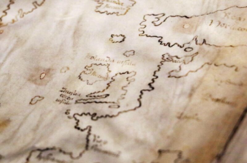
Scholars have questioned the authenticity of a purported 15th-century map housed in Yale University's Beinecke Rare Book & Manuscript Library since it was first unveiled to the public in 1965. About the size of a placemat, the Vinland Map is an intriguing document because, in addition to Africa, Asia, and Europe, the map depicts a section of the North American coastline identified as "Vinlandia Insula" just southwest of Greenland. This suggested that Norsemen may have been the first Europeans to discover the Americas, well before the first voyage of Christopher Columbus. But evidence that the map is a hoax has been steadily accumulating, particularly over the last few years. And the latest scientific analysis has definitively put an end to the controversy once and for all: the inks used to draw the map are of modern origin.

"The Vinland Map is a fake," said Raymond Clemens, curator of early books and manuscripts at the Beinecke. "There is no reasonable doubt here. This new analysis should put the matter to rest."

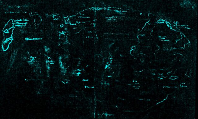
Yale's Institute for the Preservation of Cultural Heritage subjected the ink to X-ray fluorescence spectroscopy to identify how various elements were distributed throughout the map. That gave the team a "big picture" data set, rather than focusing on individual points.

The conservators found no sign of iron, sulfur, or copper, which would be typical of a medieval iron-gall ink. As for the Vinland Insula portion of the map, there were high levels of titanium and small amounts of barium, consistent with commercially manufactured white pigments in the 1920s.

vinland2-640x386.jpg


Macro X-ray fluorescence spectroscopy (XRF) revealed the presence of titanium throughout the map's lines and text.

For comparison, the team also analyzed the inks used in 50 15th-century medieval manuscripts in the Beinecke's collection, all containing significantly lower amounts of titanium than the inks used to draw the map, as well as much higher levels of iron. A follow-up analysis using field emission scanning electron microscopy (FE-SEM) ruled out the possibility that the anatase could be naturally occurring.

So the Vinland Map is most definitely a modern forgery.

https://arstechnica.com/science/202...-map-is-definitely-a-fake-new-analysis-finds/

maximus otter
 
Back
Top