• We have updated the guidelines regarding posting political content: please see the stickied thread on Website Issues.
bent-coat-hangers-in-old-pens arrangement?
This has been an oft-repeated procedural technique, presumably wherein to eliminate biofeedback effects from the holding party's hands (playing devil's advocate, I think it would still permit, indeed, magnify) subconscious shoulder and forearm movements. There will have been a first-ever televisual broadcast of this 'pseudoscientificated' version of browsing, back in the classic early 3C+C4 days of TV, I do think it would've been a significantly-affirming and imprinting experience to have seen the programme.

You've got me most intriged about the light-slit silver box (which, genuinely or not, seems strongly-familiar to me....perhaps it's a metamemory). The presence of a reflector/lightsource and columnator slit, pushing out a beam of coherent brightness across a mile or more of darkened heath and moor is a powerful image, but: does this become almost a 'homeopathic' physics experiment? What putative lasting effect is striped across the land? It's a 1:1 scale photonic picture, lasting a short time within our visual spectrum...if only it somehow could be proven to be more.
 
Last edited:
BTW, how wide is a 'real' ley line supposed to be? They look impressive on maps, but with Google Earth one can see the 'aligning sites' are in a very wide line!
That's good question. I worked on the basis that the 'line' was 10m wide, based on an initial pair of 'points' However, if you (say) take two 10m lines bases on the maximum error on one point and minimum on the other and then work the other way around, you find a great big swath of area 'in the middle' between the two 'lines' So with two 10m wide points, you've got a lot of possible 'lines'.

So (I said to myself) one can then make the width '20m', '30m' etc. to close this down, but the conclusion you arrive at after running a few sets of map data is "A wider line-width gets you more alignments". a 1m 'line width' never aligned anything up at all...

It simply not possible to plot a single line with anything like accuracy from (say) two tumuli which are 10m and 15m wide respectively...Even the idea that you can plot a line and then measure just the perpendicular distance of a third point from it is undermined by the error on the initial two points.

The only way might be to take a good GPS to a site and get a bang on long/lat from the centers. Assuming there is one and you can calculate it and get to it.

Like I said before the only conclusion I drew was you get more lines if you have more data points. A corollary to that might be that "You can't measure anything accurately enough to prove a line exists anyway".
 
This has been an oft-repeated procedural technique, presumably wherein to eliminate biofeedback effects from the holding party's hands (playing devil's advocate, I think it would still permit, indeed, magnify) subconscious shoulder and forearm movements. There will have been a first-ever televisual broadcast of this 'pseudoscientificated' version of browsing, back in the classic early 3C+C4 days of TV, I do think it would've been a significantly-affirming and imprinting experience to have seen the programme.

I tired this as a youth and thought it worked, the movements of the rods felt quite real. So I single-blind attempted to find water pipes under a courtyard, then checked my 'reading's with plans (where I worked). Nope. I 'found' nothing.

You've got me most intriged about the light-slit silver box (which, genuinely or not, seems strongly-familiar to me....perhaps it's a metamemory). The presence of a reflector/lightsource and columnator slit, pushing out a beam of coherent brightness across a mile or more of darkened heath and moor is a powerful image, but: does this become almost a 'homeopathic' physics experiment? What putative lasting effect is striped across the land? It's a 1:1 scale photonic picture, lasting a short time within our visual spectrum...if only it somehow could be proven to be more.

I like that idea, I might try that to see how good the beam is.
 
one of the issues with "how wide is a leyline" is that the answer changes depending on when it was identified, or when you asked the question.

Leys started off being physical pathways for trade and travel. More recently they turned into spirit paths, and single purpose pathways for transporting coffins.

and the physical requirements/characteristics changed through time.

I accept that Ley Lines aren't "real". But they most certainly are in my own psycho-geography! :drink:
I d

I don't know if its that recently they have turned into spirit paths, I came across this regarding the Scottish song ... http://www.darachweb.net/SongLyrics/LochLomond.html
 
Mont St Michel is actually over a hundred miles south of the St Michael Line (although it does have historical links with Cornwall's St Michael's Mount).

The map on the spiralwave website illustrates the problem with leylines - these sites are not on the same straight line! So which sites are included is purely subjective.

My computer progs had a variable 'error factor', and - surprise, surprise - the larger the error I allowed, the more leys I found!

What really convinced me that leys are just random alignments was the fact that I found just as many when I used things like phone boxes and pubs/hotels instead of ancient sites like churches, etc!

EDIT: The fact that the St Michael line is one of the longest lines in southern Britain is the reason it contains so many sites. My analysis of Cornish sites found many more leys with a SW-NE orientation - purely because this reflects the shape of the peninsular. (A NW-SE direction quickly ends up in the sea!)

I happened to see part of a BBC tv programme tonight that had some quite-stunning footage taken by drone camera whilst a group of modern-day pilgrams stride out the 7km over the sands to the iconic Mont St Michel (see http://www.bbc.co.uk/iplayer/episode/b08y6771 ) .

No mention in this Christian tv programme of ley lines (of course) but plenty of explanations regarding the historical and ancient religious links between Mont St Michel and the Cornish version (both island, and priory) at St. Michael's Mount, near Land's End (@rynner2 you may be interested).

It's many years since I was down near the Cornish 'Michaelmount', and also quite a while since I was drawing attention to the new-to-me historical/geographical parallels between these two places (all of which I was quite-oblivious to, but are in reality fully-documented). A link to my previous post on this... http://forum.forteantimes.com/index.php?threads/the-lone-coastguard-ii.58311/page-17#post-1496024

2017-07-09 22.19.12.png


It's fascinating to hear that the French Abbot sent the Saint Michel island over the Channel to Cornish St. Michael's Mount, to toughen them up.

Anyway: I know there is a lot of doubt and discreditation regarding ley lines, but they still fascinate me (even if they become totally-debunked, they are still interesting concepts).

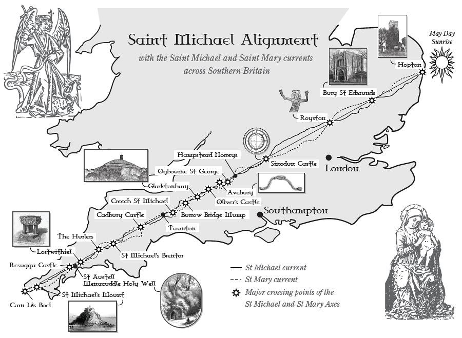
The St Michael (Ley) Line is an especially-interesting one (yes, I know, any points can be joined-up to form conjuctions and lines, but it is still intriguing).

6047282919_7dd9dd41f7_b.jpg

And in any case, it's a long time since we've had any ley line lore upon the Forum (who knows, it might ignite an article within the pages of FT itself, on this quintessentially-Fortean topic).

I was intrigued to read in this article http://bigthink.com/strange-maps/527-the-st-michael-line-a-straight-story that allegedly The Line also passes through Mont St Michel, over in France.

Now, I do doubt this: but, the idea is so gripping as a concept, and magnified by those intrepid BBC Songs of Praise pilgrims tonight striding along the water/sand in a 7km straight line to Mont St Michel, perhaps with a straight line behind them, all the way to Land's End and Hopton/Bury St Edmunds...well, it was all just a bit of a Fortean moment.:cool:

Please do pitch-in with your opinions / perspectives / responses. As I'm sure you will!
 
Last edited:
Not syre if this is the right place but it does touch upon ley lines...

I watched this video over the weekend and thought it was very good.

Worth starting at approx 15 minutes to see if it is of any interest and then going back and starting from the beginning where it is a bit technical

 
Mmm. Some interesting stuff about magnetism, although neither diamagnetism nor paramagnetism are 'new categories of magnetism' as described in the inserted video. He's also someone who throws 'frequency' about without understanding the concept. I stopped watching when he just made up nonsense about "every light frequency has a sound frequency attached to it". And not one person in the audience stood up and asked him to explain that! How are these frequencies matched? What sound frequency is 600 Angstroms - a very specific orange? What colour is 7.78 Hz or 27 kHz?

It's as bad as those charlatans who go about talking about 'energy fields' without understanding the phrase or defining anything about it. (Oh, I just skipped forward at random and guess what? He's waffling on about "energy generating devices". No definition of this energy of course...)

A classic example of pseudo science paraded in front of a willing but uncritical audience.

Sorry XBerMann, you posted it in good faith I'm sure...
 
I've always found the concept of ley lines fascinating. In the 1970s a friend and I got an OS map of the Isle on Mann and drew up dozens of sites in lines of more than four. IoM was good as it has not been greatly developed. Although I did wonder that if we'd chosen sweet shops, post offices, cross roads and petrol stations we'd also get plenty of lines!

Can anyone tell me how wide a ley line is? Drawing stuff on OS maps can look impressive, until you look more carefully on Google Maps or Google Earth and discover these objects/sacred sites are not in very straight lines al all.

I remember a TV documentary 30-odd years ago where they laid down a temporary ley line to be detected by dowsers. They used a wooden box lined with aluminium foil. In the box was a bight car headlamp. On one side of the box was a slot about an inch wide in the foil lining. The dowsers couldn't detect it after a week or so.

Sounds like an excellent experiment to recreate. Does anyone remember the TV programme?
 
I remember a TV documentary 30-odd years ago where they laid down a temporary ley line to be detected by dowsers. They used a wooden box lined with aluminium foil. In the box was a bight car headlamp. On one side of the box was a slot about an inch wide in the foil lining. The dowsers couldn't detect it after a week or so.
Why would they?
 
Why would they what? I guess the premise was that whatever a ley line is, it can be detected by dowsers and this man-made one fades away. Of course one has to assume the whole thing was not faked,..
Why would they detect it? It's not a ley line.
 
Why would they detect it? It's not a ley line.

They did supposedly detect it for a while, that's the point. Whatever a ley line is, the field detectable by dowsers can be laid down artificially. But then perhaps you can explain what a ley line consists of - assuming they are nothing more than alignments of sites and not also 'energy' lines.
 
They did supposedly detect it for a while, that's the point. Whatever a ley line is, the field detectable by dowsers can be laid down artificially. But then perhaps you can explain what a ley line consists of - assuming they are nothing more than alignments of sites and not also 'energy' lines.
I have no idea what a ley line might be, but I suspect it is just a route that many people have travelled for reasons best known to themselves. They are usually routes between notable landmarks and places of historical significance. Perhaps over time, some of that 'human experience' or (as woo people might say) 'energies' may have been stored like a 'stone tape' along those routes?
I find it hard to believe that myself, mind - I have no idea how that would work scientifically.
 
I don't think it would work scientifically - weren't ley lines made up in the 1930s?
 
I don't think it would work scientifically - weren't ley lines made up in the 1930s?

The use of landmarks and other sites as guides for trading or pilgrimage routes may well be prehistoric, but I suspect you're right about the other woo now associated with them which started relatively recently.
 
Mmm. Some interesting stuff about magnetism, although neither diamagnetism nor paramagnetism are 'new categories of magnetism' as described in the inserted video. He's also someone who throws 'frequency' about without understanding the concept. I stopped watching when he just made up nonsense about "every light frequency has a sound frequency attached to it". And not one person in the audience stood up and asked him to explain that! How are these frequencies matched? What sound frequency is 600 Angstroms - a very specific orange? What colour is 7.78 Hz or 27 kHz?

It's as bad as those charlatans who go about talking about 'energy fields' without understanding the phrase or defining anything about it. (Oh, I just skipped forward at random and guess what? He's waffling on about "energy generating devices". No definition of this energy of course...)

A classic example of pseudo science paraded in front of a willing but uncritical audience.

Sorry XBerMann, you posted it in good faith I'm sure...


Thanks for your input I am an investment banker by trade so the techie stuff was above my pay grade meaning I have to take it as it comes or ignore it.

I obviously should have ignored this one
 
Does anyone know of a detailed British ley line map? Someone I know says he's seen one which shows a ley line passes through his property and 'explains' some strange goings on locally.

I've had a bit of a Google but not found anything with much detail.

Thanks.

BB
 
Last edited:
Does anyone know of a detailed British ley line map? Someone I know says he's seen one which shows a ley line passes through his property...

Generate your own, it won't be difficult:

Simply push a pin into an OS map showing his address, then set the middle of a ruler against it. Now rotate the ruler about the pivot point of the pin until its edge touches two or more landscape features, e.g hilltops, wayside crosses, ancient churches etc.

Hey presto! The house is on a ley line! Now every time he loses his car keys...

Archaeological Theory: An Introduction

Eight-point alignment of pizza restaurants in London:

Pizzalines8.png


https://en.wikipedia.org/wiki/Ley_line#Criticism

maximus otter
 
Didn't people use to make their own by joining up possible weird sites on maps?
Had a go myself back in the day!
 
Back in the day an erstwhile poster here tried to plot something similar to the Glastonbury Zodiac, but using an OS map of the Calder Valley, that being where he was based. In his words, it was a tongue-in-cheek endeavour, but to his amazement, he was able to locate all 12 signs.

I spoke to him about this some years later. The detail I remember most clearly, and that he found genuinely quite Fortean, was that the tip of that part of the Taurean anatomy which makes him unambiguously a bull coincided with a well.
 
Last edited:
Does anyone know of a detailed British ley line map? Someone I know says he's seen one which shows a ley line passes through his property and 'explains' some strange goings on locally.

I've had a bit of a Google but not found anything with much detail.

Thanks.

BB
Let me know if anything pops up! I've been looking as well :)
 
Back in the day an erstwhile poster here tried to plot something similar to the Glastonbury Zodiac, but using an OS map of the Calder Valley, that being where he was based. In his words, it was a tongue-in-cheek endeavour, but to his amazement, he was able to locate all 12 signs.
As I understand it, the area of said zodiac was mostly under tidal marshes when it was allegedly constructed.

Ley Lines:

I wrote a program in the 1980's to find 'ley-lines'. Specifically, it allowed one to input the map references of 'points of interest' on a 1:50000 map and then search then entire entry list for alignments. It took every possible pair or points, plotted a straight line and worked out the perpendicular distance of every other point from the line. More than '3' counted as a 'ley' (I wrote to Tom Graves and he sent me a nice letter with some good advice.)

The program allowed for the relative sizes of objects and so calculated a line from one side of object 'a' to the other side of object 'b'. Both lines were then cross check against all the other entries. It allowed allowed for the identification of the point (say 'tumulus' or 'church'), and also worked with large earthworks. The program allowed you to exclude two sorts of features from a calculation. So leave out 'churches' for example.

The 'leys' were logged, saved and plotted on the screen. The program then took the original data, scattered all the points randomly within a 10/20/50/100 yard radius (user selectable) and re-calculated. This was done 10/20/50 times (user selectable) and then the 'real' map data aligments were compared with averaged findings of the total set of randomised runs. How many alignments of what length and so on. The program could run randomised sets of data on any 'map' file and add them to any previous randomised runs, so I could build up a lot of random data sets' alignments.

I manually digitised 10 x 1:50,00 maps. In none of them did the alignments found exceed randomised data. The only 'positive' result was that 'the more points you had, the more leys the program found'. But the randomised data always found about the same.

I tweaked the program and used the nominal centre of 'features' and various 'ley' widths and got the same results.

The result were duplicated using 'non mysterious' map features, like post offices and trig points. In other words, even without the use statistics it was clear that alignments were no more than chance and no more likely than any set of points taken from the maps. I used maps from Scotland, Cornwall and even the Stonehenge area.

Not bad for an Amstrad CPC6128 (admittedly running overnight for some weeks).

At this time it dawned on me 'ley lines' might be madey-uppy.
 
There are no such things as ley lines :p

And no mention of them ever before 1925. Odd for such supposed ancient antiquities.
 
There are no such things as ley lines :p

And no mention of them ever before 1925. Odd for such supposed ancient antiquities.
Alfred Watkins original book actually proposed a series of tracks, that is actual roads, rather than mystical energy lines. Inasmuch that there was an iron-age road or trail system, it was a decent enough guess.
 
Back
Top