• We have updated the guidelines regarding posting political content: please see the stickied thread on Website Issues.

Anomalous Ancient Maps

blessmycottonsocks

Antediluvian
Joined
Dec 22, 2014
Messages
9,433
Location
Wessex and Mercia
Apologies if there already is a thread somewhere for this fascinating topic.

I recently read up about the cartographer Philippe Buache (1700-1773), one of whose maps is centred on Antarctica and even shows the central channel between the land masses: Buache_640.jpg
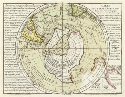
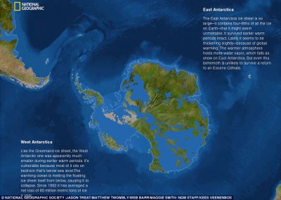
Comparing this with a recent Nat Geo image showing how Antactica would look without the ice shows significant similarities.

natgeo.jpg
Whilst we've all heard of the (in)famous Piri Reis map, I believe this one seems more anomalous, given that, at the time, cartographers should not officially even have known about Antarctica's existence, let alone have made maps of how it would have looked in the very distant past.

Any views?
 
Last edited by a moderator:
The idea of a southern continent goes back a while. Partly because they though it was needed to balance out the Earth. I've seen other drawings on the Antarctic where it's divided up and there was an explanation of why. I sadly can't recall it right now.
 
I recently read up about the cartographer Philippe Buache (1700-1773), one of whose maps is centred on Antarctica and even shows the central channel between the land masses:View attachment 1768

Comparing this with a recent Nat Geo image showing how Antactica would look without the ice shows significant similarities.

View attachment 1769
Whilst we've all heard of the (in)famous Piri Reis map, I believe this one seems more anomalous, given that, at the time, cartographers should not officially even have known about Antarctica's existence, let alone have made maps of how it would have looked in the very distant past.

Any views?
I've long been interested in ancient maps. The Earth was known to be a globe in ancient Greek times, and much of it was mapped long before modern history admits. It seems likely that the named explorers and 'discoverers', like Columbus or Magellan, had actually had access to libraries of ancient maps, which to a greater or lesser extent guided their travels.

Can't think of any killer quotes atm, but I may search around when I get time.
 
Me too. I'm lucky enough to work in IT but heavily involved with mapping data, which I never grow tired of.
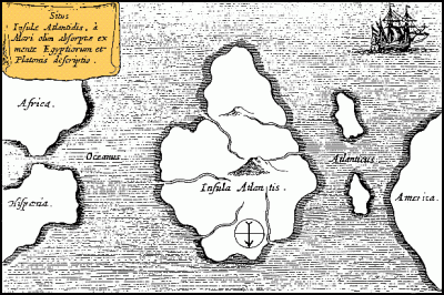
As well as the anomalous early maps of Antarctica, I have a particular interest in depictions of Atlantis, such as this:

Athanasius_Kircher's_Atlantis.gif

(South is at the top) which clearly depict Atlantis as being in the Atlantic Ocean and stretching roughly from the Canary Isles to the Azores. Given recent archaeological finds proving pre-European colonisation of the Azores, I believe they are the most likely location and source of this enduring myth.
 
England would have been joined to the continent via a strip of land called Doggerland...but that doesn't seem to be on the carving.
 
Me too. I'm lucky enough to work in IT but heavily involved with mapping data, which I never grow tired of.
As well as the anomalous early maps of Antarctica, I have a particular interest in depictions of Atlantis, such as this:

View attachment 1791

(South is at the top) which clearly depict Atlantis as being in the Atlantic Ocean and stretching roughly from the Canary Isles to the Azores. Given recent archaeological finds proving pre-European colonisation of the Azores, I believe they are the most likely location and source of this enduring myth.
Ice in Antarctica suddenly appeared suddenly in geologic terms about 35 million years ago. For the previous 100 million years the continent had been essentially ice-free where palm trees grew and dinosaurs once roamed. The map shows Antarctica with rivers which would indicate it was at least largely ice-free. Note: the coast lines remained warm until as recently as 15 or 20 million years ago. This being true the map would have to be truly ancient indeed.
 
"This being true the map would have to be truly ancient indeed."

And considering the homo genus is only supposed to be around 3 million years old and only possessing language and writing for a fraction of that time, highly anomalous.

So either;

1) Ancient cartographers made a lucky guess
2) Intelligent humankind has been around a LOT longer than conventional history tells us
3) Antarctica was free of ice FAR more recently than conventional history tells us
4) Aliens done it
 
Last edited:
"England would have been joined to the continent via a strip of land called Doggerland...but that doesn't seem to be on the carving."

Although the Netherlands and Scandinavia appear to be encroaching very closely on the British Isles, leaving virtually no North Sea.
 
"This being true the map would have to be truly ancient indeed."

And considering the homo genus is only supposed to be around 3 million years old, highly anomalous.

So either;

1) Ancient cartographers made a lucky guess
2) Intelligent humankind has been around a LOT longer than conventional history tells us
3) Antarctica was free of ice FAR more recently than conventional history tells us
4) Aliens done it
Were fortunate to live in a world that still has it's riddles.
 
As an addendum to this thread, I should point out that there are two extant Buache maps from around 1739.

The first one is not at all anomalous for the time, as it shows Antarctica as a featureless unknown:

map1.JPG


The second map, shows Antarctica as a land mass with a central channel:

map2.JPG

It is worth pointing out though that Buache annotated the Antarctica portion of this latter map with the words conjecturée (conjectured) and soupçonnée (suspected).
In other words, he was guessing what Antarctica, subglacial or not, actually looked like.

This obviously diminishes the woo factor a bit but, even if monsieur Buache was merely indulging in speculation about what was at that time the mysterious Terres Australes, it turned out to be one hell of a good guess!
 
Back
Top