- Joined
- Jul 19, 2004
- Messages
- 29,622
- Location
- Out of Bounds
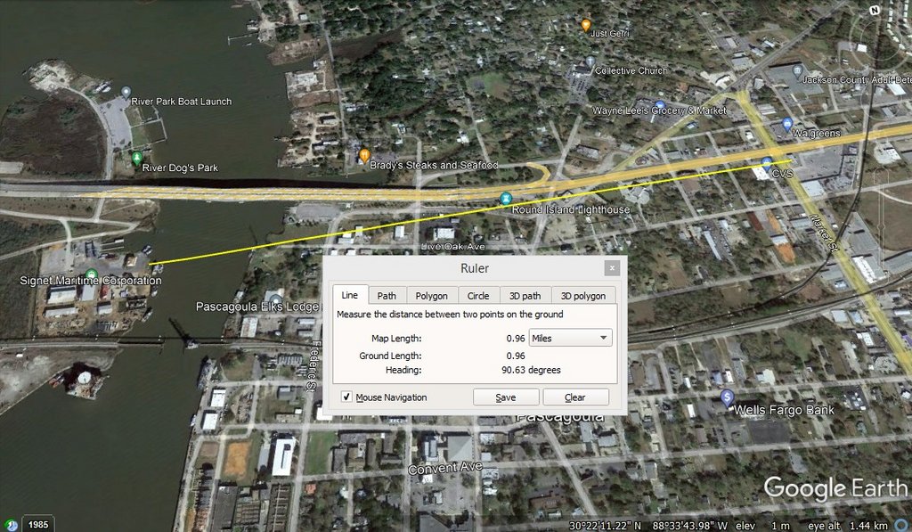
Next ... At the very beginning of the video Calvin points to the inlet / embayment adjacent to where he's standing and says he doesn't remember that water being there (i.e., on the side of the scene opposite the bridge to the north). He says the terrain on that side of the actual incident scene was filled in (i.e., solid ground).
Now look at the 1973 / 1974 photo of the scene published by the Mississippi Press Register in their booklet:

Notice the inlet / embayment at the extreme left of the photo. This is the very same embayment Calvin alludes to in the video as something he doesn't remember. This embayment's shore profile (to the extent it survives) is the same between this photo and current aerial imagery. The concrete(?) blocks lining the embayment's northern shore (barely visible at the extreme left margin of the 1973 / 1974 photo) can still be discerned in today's aerial imagery. The dirt road and water tank(?) in this old photo have been obliterated by subsequent landfill and construction of the current Signet facility.
Calvin doesn't remember there being water immediately south of the incident scene because he's not standing at the incident scene. The 1973 / 1974 photo correctly illustrates the filled-in area south of the embayment and extending out into the river (with at least 3 piers / docks) as the area in which the incident occurred. It was in this area where the 1970s-era photos of the alleged pier scene were taken.
The Signet construction has covered over and extended the 1973 shoreline.
Here's an illustration of all these points ...

Now look at the 1973 / 1974 photo of the scene published by the Mississippi Press Register in their booklet:
Notice the inlet / embayment at the extreme left of the photo. This is the very same embayment Calvin alludes to in the video as something he doesn't remember. This embayment's shore profile (to the extent it survives) is the same between this photo and current aerial imagery. The concrete(?) blocks lining the embayment's northern shore (barely visible at the extreme left margin of the 1973 / 1974 photo) can still be discerned in today's aerial imagery. The dirt road and water tank(?) in this old photo have been obliterated by subsequent landfill and construction of the current Signet facility.
Calvin doesn't remember there being water immediately south of the incident scene because he's not standing at the incident scene. The 1973 / 1974 photo correctly illustrates the filled-in area south of the embayment and extending out into the river (with at least 3 piers / docks) as the area in which the incident occurred. It was in this area where the 1970s-era photos of the alleged pier scene were taken.
The Signet construction has covered over and extended the 1973 shoreline.
Here's an illustration of all these points ...